| Tweet |

Custom Search
|
|
 
|
||
|
Military
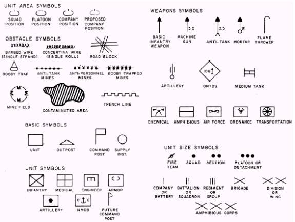
Symbols In addition to topographic symbols used to represent natural and man-made features of the earth, the military establishment requires some method for showing the identity, strength, locations, and movements of its troops, activities, and installations. The symbols used to represent these features are known as military symbols. As these features are constantly changing and moving, they are not normally printed on the maps. They appear on special maps and overlays and are handled by
Figure 5-23.-Typica1 military symbols. following proper security precautions. Figure 5-23 shows many of these symbols. Care
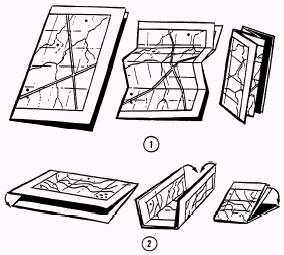
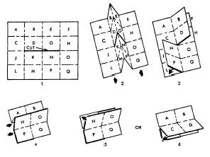
of Maps One of the first precautions in caring for maps is folding the map properly. Figures 5-24 and 5-25 show ways of folding maps to make them small enough to be carried easily and still be available for use without having to unfold them entirely. Your maps may have to last a long time, so protect them as best you can. Whenever possible, carry a map in a waterproof packet, in a pocket, under an outer garment, or other place where it is handy but still protected. In marking a map, use light lines that maybe erased easily without smearing, smudging, or leaving marks that may later tend to confuse someone. If you must trim the margins of a map for any reason, be careful to copy any marginal information that may be needed later, such
Figure 5-24.-Two methods of folding a map. Figure
5-25.-How to slit and fold. as grid and magnetic declination data or overlapping grid values and ticks. |
||
|
||