| Tweet |

Custom Search
|
|
 
|
||
|
Base
Line In order to measure anything, there must always be a starting point, or zero measurement. To express a direction as a unit of angular measure, there must be a starting point, or zero measure, and a point of reference. These two points designate the base, or reference, line. There are three base lines-true north, magnetic north, and grid north. Those most commonly used are magnetic and grid; the magnetic when working with a compass, and the grid when working with a military map. TRUE NORTH. This is a line from any position on the surface of the earth to the North Pole. All lines of longitude are true north lines. True north is usually symbolized by a star (fig. 5-21). MAGNETIC NORTH. The direction to the magnetic North Pole is indicated by the north-seeking needle of a magnetic instrument. Magnetic north is usually symbolized by a half arrowhead (fig. 5-21). GRID NORTH. This is the north established by the vertical grid lines on the map. Grid north may be symbolized by the letters GN (fig. 5-21). Topographic
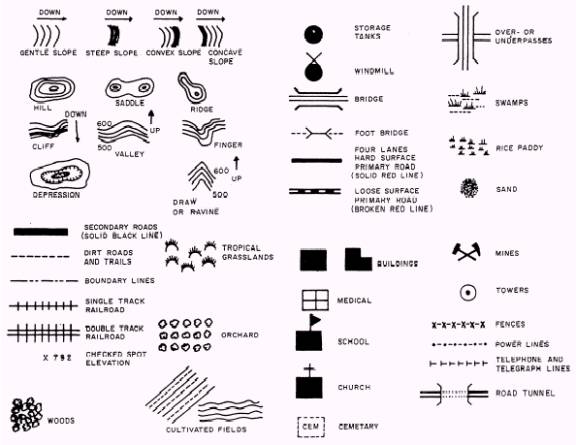
Map Symbols The purpose of a topographic map is to permit you to visualize an area of the surface of the earth with
Figure 5-22.-Topographic symbols. pertinent features properly positioned. Ideally, all features within an area would appear on the map in their true proportion, position, and shape. However, this is not practical. Many of the features would be-unimportant and others could not be recognized because of their reduction in size. Therefore, the map maker has been forced to use symbols to represent these features. These symbols resemble, as closely as possible, the actual features themselves. (See fig. 5-22.) Topographic symbols are usually printed in a number of standardized colors. This is done so the features on the map are easier to identify and to give them a more natural appearance and contrast. Black-the majority of cultural or man-made features Blue-water features, such as lakes, rivers, and Swamps Green-vegetation, such as woods, orchards, or vineyards Brown-all relief features, such as contours Red-main roads, built up areas, and special features Others-occasionally used to show special information; generally, explained in the marginal notes |
||
|
||