|
||
|
|
||
|
Page Title:
Low-level jet at the top of a radiation inversion |
||
| |||||||||||||||
|
|
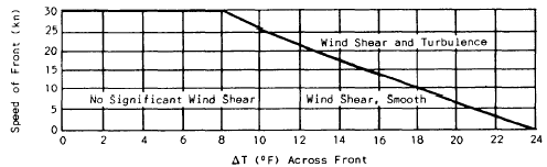
LOW-LEVEL JET AT THE TOP OF A RADIATION INVERSION. A low-level jet often forms just above a radiation inversion. It starts to form at sundown, reaches maximum intensity just before sunrise, and is destroyed by daytime heating (usually by 10 a.m. local time). The low-level jet is observed in all parts of the world at all times of the year. In the United States it is common in the Great Plains and the Central states. Radiational cooling creates a calm, stable dome of cold air 300 to 1,000 feet thick, termed an inversion layer. The low-level jet occurs just above the top of the inversion layer, and while speeds of 30 knots are common, windspeeds in excess of 65 knots have been reported. Anytime a radiation inversion is present, the possibility of low-level wind shear exists.FUNNELING WINDS AND MOUNTAIN WAVES. Certain airports are infamous for having treacherous winds. These winds are caused by funneling; that is, the terrain is such that the prevailing winds force a large mass of air to be channeled through a narrow space (such as a canyon), where it is accelerated, and then it spills out into the flightpath of aircraft. These winds Figure 6-1-8.-Frontal wind shear/turbulence guide. sometimes reach velocities of 80 knots. Caution is required when operations are conducted near mountains or along straits and channels. Mountain waves often create low-level wind shear at airports downwind of the wave, While altocumulus standing lenticular (ACSL) clouds are not a prerequisite, they usually indicate the presence of mountain waves, and they are clues that shear should be anticipated. |
|
Privacy Statement - Press Release - Copyright Information. - Contact Us - Support Integrated Publishing |