|
||
|
|
||
| |||||||||||||||
|
|
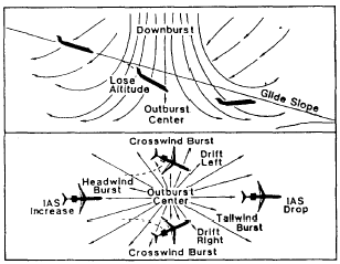
LOW-LEVEL WIND SHEAR Wind shear is a change in wind speed and/or direction over a short distance, which results in a tearing or shearing action. Although wind shear can occur at any altitude, it is particularly hazardous when it happens over a short period of time and within 2,000 feet of the ground, during takeoff or landing. During this phase of flight, the aircraft operates only slightly above stall speed, and a major change in wind velocity can lead to a loss of lift. If the loss is great enough that power response is inadequate, it results in a steep descent. The altitude at which the encounter occurs, pilot reaction time, and airplane response capability determine if the descent can be altered in time to prevent an accident.The time dependency of significant low-level wind shear can best be illustrated through example: Suppose that an aircraft flying into a headwind of 30 knots were to fly through a gradually changing wind pattern such that 1 hour later the headwind had become a tailwind of 30 knots. The effect of such a gradual shear would be negligible. But if the same change were to occur within a few seconds, the aircrew would have to make rapid, positive inputs to maintain control of the aircraft.Weather Causing Low-Level Wind Shear Several weather phenomena produce low-level wind shear. Included are thunderstorms, fronts, low-level jets at the top of a radiation inversion, and funneling winds and mountain waves.THUNDERSTORMS. The winds around a thunderstorm are complex. Downdrafts or micro-bursts exiting the base of a thunderstorm spread outward in all directions upon approaching the surface and form an area of gustiness near the thunderstorm. The outer limit of this gusty area is referred to as the gust front. Figure 6-1-6 shows a cross section of a typical gust front.The thunderstorm downdraft may produce the most dangerous shear conditions associated with the outflow of a thunderstorm. The gust front frequently extends 10 to 15 miles away from the thunderstorm. Extreme wind shears of 10 knots per 100 feet of altitude have been measured immediately behind the gust front, while horizon-tal wind shears of 40 knots per mile have been recorded across the gust front. In addition to the tremendous speed shears reached, the most severe thunderstorms produce directional shears of 90 to 180. See figure 6-1-7.Wind shear associated with thunderstorms is by far the most hazardous, because of the complexity and multiplicity of the shears
Figure 6-1-6.-Common features of a gust front.
Figure 6-1-7.-Microburst effects on aircraft. produced. Prevailing low-level winds are forced up over the gust front; currents that feed into the storm are present; and more than one gust front may be encountered, because of multiple down-drafts. In addition, extreme downdrafts may occur beneath the central region of the storm. FRONTS. Winds can be significantly different in two air masses forming a front. Fronts that are most conducive to significant wind shear are fast moving (30 knots or more) and/or have at least a 5C (10F) temperature differential. Figure 6-1-8 may be used as a general guideline to determine if a front will have wind shear and/or turbulence associated with it. Low-level wind shear occurs with a cold front after the front passes. Because cold fronts have a greater slope and normally move faster than warm fronts, low-level wind shear usually lasts less than 2 hours. The wind shear associated with a warm front is more dangerous to airport operations. Strong winds aloft, associated with the warm front, may cause a rapid change in wind direction and speed where the warm air overrides the cold, dense air near the surface. Warm-frontal wind shear may persist 6 hours or more ahead of the front because of the fronts shallow slope and slow movement. Further, low ceilings and risibilities frequently associated with warm fronts may compound air-crew problems. |
|
Privacy Statement - Press Release - Copyright Information. - Contact Us - Support Integrated Publishing |