|
||
|
|
||
|
Page Title:
Distribution of Clouds and Turbulence |
||
| |||||||||||||||
|
|
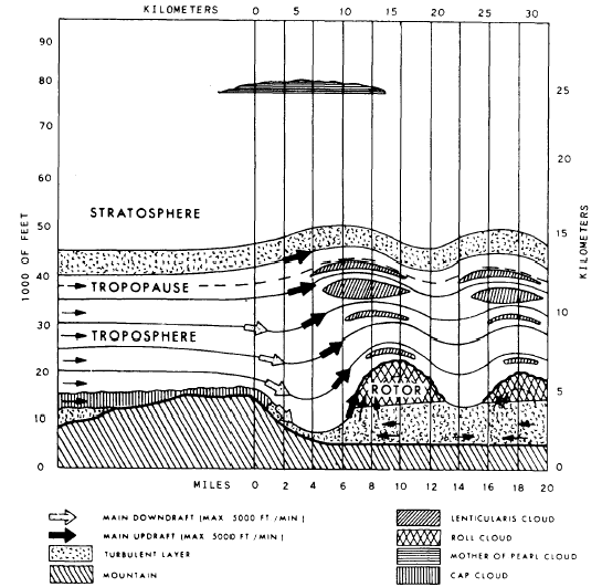
Distribution of Clouds and Turbulence. Specific clouds are associated with the mountain wave condition. They are the cap (foehnwall), rotor or roll, lenticular, and nacreous (mother-of- pearl) clouds. Figure 6-1-5 illustrates the
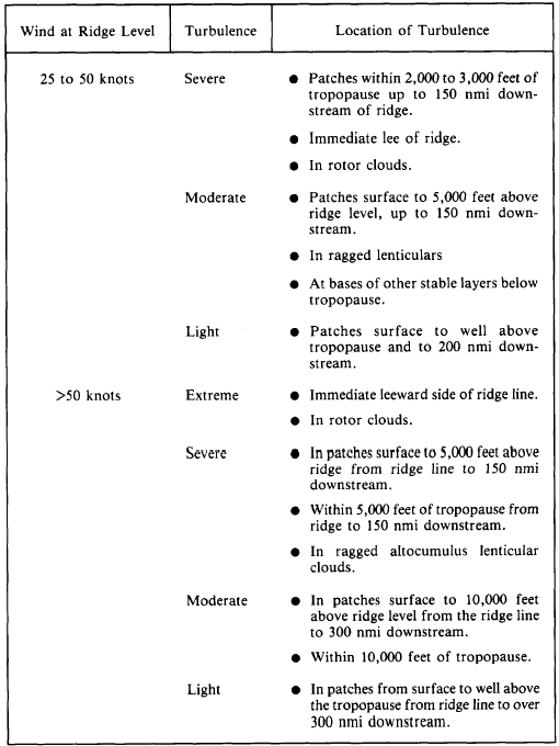
Figure 6-1-5 .-Mountain wave structure. structure of a strong mountain wave and the associated cloud patterns. The lines and arrows illustrate the wind flow from left to right. The cap cloud hugs the tops of the mountains and flows down the leeward side with the appearance of a waterfall. This cloud is dangerous because it hides the mountain and has strong downdrafts. The downdrafts may be as strong as 5,000 feet per minute.The roll or rotor cloud looks like a line of cumulus clouds parallel to the ridge line. It forms on the lee side and has its base near the height of the mountain peak, with its top extending considerably above the peak. The tops may extend to twice the height of the highest peak. The rotor often merges with the lenticulars above, forming a solid mass to the tropopause. Rotor clouds are noted for their ragged leeward edge, where it appears the cloud is being torn apart. The rotor cloud is dangerously turbulent. It has updrafts up to 5,000 feet per minute (83 feet per second) on the windward edge, and downdrafts up to 5,000 feet per minute on the leeward edge. This cloud is stationary, constantly forming on the leading edge and dissipating on the trailing (downwind) edge. The primary or first roll cloud may form immediately on the lee side of the mountain, or it may form up to 10 miles downstream from the mountain ridge. Several successively weaker bands of roll clouds may form at intervals downstream from the primary roll cloud and merge into a stratocumulus cloud formation. The stratocu-mulus clouds also form bands paralleling the mountain peaks. The ragged rotor appearance is less evident in each succeeding band, and the tur-bulence is less extreme with each band. These bands are very evident on satellite imagery and are often seen extending 150 to 300 miles down-wind of a mountain range.The lenticulars are lens-shaped clouds with bases above the primary roll cloud. The tops may extend to 40,000 feet. They may have a tiered or stacked shape due to the stratified moisture of the atmosphere. The lenticulars may or may not have turbulence associated with them. If they have smooth edges, there is no turbulence; if the edges are ragged, the aircrew should expect turbulence.In the polar regions a high stratospheric lenticular cloud often appears to be associated with a mountain wave. These clouds are called nacreous, or mother-of-pearl, clouds and form in the vicinity of 80,000 feet.The clouds in the mountain wave form in pyramids on the lee side of mountains. They are usually tilted backward toward the mountain. One pyramid may form; a series of pyramids extending downstream may form; or no clouds at all may form. The appearance of clouds in a mountain wave depicts the existence of turbulence with sufficient moisture to form clouds. The lack of clouds means only that there is insufficient moisture for cloud formation; turbulence may still be present.The winds blowing across the mountains (which produce the mountain wave) also produce a notable pressure deviation, which can in itself be hazardous during IFR conditions. Anticipate station pressures and altimeter settings within 50 nmi of the windward side of the mountain to be as much as two-tenths of an inch (7 millibars) higher than anticipated, and pressures within 50 nmi of the leeward side to be as much as two-tenths of an inch lower than anticipated. One source cites a 1-inch (35 millibars) altimeter deviation in the immediate lee side of steep mountains under high wind conditions. The buildup of mass will produce a windward side high-pressure ridge and a leeward side low-pressure trough. Pressure fluctuations will continue downwind but with rapidly decreasing intensity. An aircraft flying a low-level route during IFR conditions approaching the mountain from the windward side would see an indicated altitude on the pressure altimeter lower than he is actually flying, and would correct by adding altitude. This would increase his margin of safety crossing the mountain peaks. However, the same aircraft flying from the leeward side to the wind-ward side would encounter the lee side trough, see an indicated altitude higher than that actually being flown, and compensate by decreasing his altitude. A two-tenths-of-an-inch altimeter deviation would roughly equate to about two hundred feet. While fighting the downdraft in the soup of the cap cloud, a shirt-tail flyer may count on that extra 200 feet of altitude (which he never had) to "just squeeze over" the top of the mountain.The most dangerous feature of the mountain wave is the turbulence located in the cap and the rotor cloud. The downdrafts in these clouds can force an aircraft into the mountain. Pilots investigating mountain waves have reported that they experienced more hazardous flight conditions in the wave than they encountered in any thunderstorm. Mountain waves have produced gust velocity measurements of 50 feet per second at 30,000 feet. Some aircraft will experience structural failure when encountering gusts of 50 feet per second at reduced speeds or 35 feet per second at ordinary speeds. Table 6-1-4 is a summary of areas of turbulence during mountain wave conditions.Table 6-1-4.-Mountain Wave Turbulence Guide
Learning Objective: Identify the weather phenomena that can produce low-level wind shear. |
|
Privacy Statement - Press Release - Copyright Information. - Contact Us - Support Integrated Publishing |