 |
||
|
|
||
|
Page Title:
Modification of the Icing Forecast |
||
| |||||||||||||||
|
|
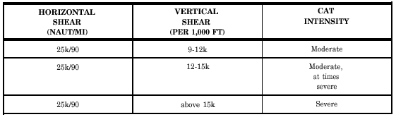
Click here to Order your Radar Equipment Online Modification of the Icing Forecast The final phase is to modify your icing forecast. This is essentially a subjective process. The forecaster should consider the following items: probable intensification or weakening of synoptic features, such as low-pressure centers, fronts, and squall lines during the time interval between the latest analysis and the forecast; local influences, such as geographic location, terrain features, and proximity to ocean coastlines or lake shores, and radar weather observations and pilot reports of icing. The forecaster should be cautious in either underforecasting or overforecasting the amount and intensity of icing. An overforecast results in a reduced payload for the aircraft due to increased fuel load, while an underforecast may result in an operational emergency.TURBULENCE LEARNING OBJECTIVES: Recall characteristics associated with turbulence. Determine the four intensities of turbulence. Forecast surface, in-cloud, and clear air turbulence (CAT). Recognize the advantages of the use of Doppler radar in turbulence forecasting.Turbulence is of major importance to pilots of all types of aircraft; therefore, it is also of importance to the forecaster, whose duty it is to recognize situations where turbulence may exist, and to forecast both the areas and intensity of the turbulence. The following text discusses the classification and intensity of turbulence, the forecasting of turbulence near the ground, the forecasting of turbulence in convective clouds, and the forecasting of clear air turbulence (CAT). Refer to the AG2 TRAMAN, volume 2, unit 6, for a discussion of the types and properties of turbulence.TURBULENCE CHARACTERISTICS Turbulence may be defined as irregular and instantaneous motions of air that are made up of a number of small eddies that travel in the general air current. Atmospheric turbulence is caused by random fluctuations in the windflow. Given an analyzed wind field with both streamlines and isotachs smoothly drawn, any difference between an actual wind and this smooth field is attributed to turbulence.To an aircraft in flight, the atmosphere is considered turbulent when irregular whirls or eddies of air affect the motion of the aircraft, and a series of abrupt jolts or bumps is felt by the pilot. Although a large range of sizes of eddies exists in the atmosphere, those causing bumpiness are roughly of the same size as the aircraft dimensions, and usually occur in an irregular sequence imparting sharp translation or angular motions to the aircraft. The intensity of the disturbances to the aircraft varies not only with the intensity of the irregular motions of the atmosphere but also with aircraft characteristics, such as flight speed, weight stability, and size.Wind Shear and CAT A relatively tight gradient, either horizontal or vertical, produces churning motions (eddies), which result in turbulence. The greater the change of wind speed and/or direction, the more severe the turbulence. Turbulent flight conditions are often found in the vicinity of the jetstream, where large shears in the horizontal and vertical are found. Since this type of turbulence may occur without any visual warning, it is often referred to as CAT.The term clear air turbulence is misleading because not all high-level turbulence included in this classification occurs in clear air. However, the majority (75 percent) is found in a cloud-free atmosphere. CAT is not necessarily limited to the vicinity of the jetstream; it may occur in isolated regions of the atmosphere. Most frequently, CAT is associated with the jetstream or mountain waves. However, it may also be associated with a closed low aloft, a sharp trough aloft, or an advancing cirrus shield. A narrow zone of wind shear, with its accompanying turbulence, is sometimes encountered by aircraft as it climbs or descends through a temperature inversion. Moderate turbulence may also be encountered momentarily when passing through the wake of another aircraft.The criteria for each type of CAT areas follows: . Mountain wave CAT. Winds 25 knots or greater, normal to terrain barriers, and significant surface pressure differences across such barriers.. Trough CAT. That portion of a trough that has horizontal shear on the order of 25 knots, or more, in 90 nautical miles.. Closed low aloft CAT. If the flow is merging or splitting, moderate or severe CAT maybe encountered. Also, to the northeast of a cutoff low aloft, significant CAT may be experienced. As with the jetstream CAT, the intensity of this type of turbulence is related to the strength of the shear.. Wind shear CAT. Those zones in space in which wind speeds are 60 knots or greater, and both horizontal and vertical shear exists, as indicated in table 5-1. No provision is made for light CAT because light turbulence serves only as a flight nuisance. Any of the above situations can produce moderate to severe CAT. However, the combination of two or more of the above conditions is almost certain to produce severe or even extreme CAT. A jetstream may be combined with a mountain wave or be associated with a merging or splitting low. Turbulence on the Lee Side of Mountains When strong winds blow approximately perpendicular to a mountain range, the resulting turbulence may be quite severe. Associated areas of steady updrafts and downdrafts may extend to heights from 2 to 20 times the height of the mountain peaks. Under these conditions when the air is stable, large waves tend to form on the lee-side of the mountains, and may extend 150 to 300 miles downwind. They are referred to as mountain waves. Some pilots have reported that flow in these waves is often remarkably smooth, while others have reported severe turbulence. The structure and characteristics of the mountain wave were presented in volume 2 of the AG2 TRAMAN. Refer to figure 6-1-5 in volume 2 for an illustration of a mountain wave. The windflow normal to the mountain produces a primary wave, and, generally less intense, additional waves farther downwind. The characteristic cloud patterns may or may not be present to identify the wave. The pilot, for the most part, is concerned with the primary wave because of its more intense action and proximity to the high mountainous terrain. Severe turbulence frequently can be found 150 to 300 miles downwind, when the winds are greater than 50 knots at the mountaintop level. When winds are less than 50 knots at the mountaintop level, a lesser degree of turbulence may be experienced. Some of the most dangerous features of the mountain wave are the turbulence in and below the roll cloud, the downdrafts just to the lee side of the mountain peaks, and to the lee side of the roll clouds. The cap cloud must always be avoided because of turbulence and concealed mountain peaks. The following five rules have been suggested for flights over mountain ranges where waves exist: 1. The pilot should, if possible, fly around the area when wave conditions exist. If this is not feasible, he/she should fly at a level that is at least 50 percent higher than the height of the mountain range. 2. The pilot should avoid the roll clouds, since these are the areas with the most intense turbulence. 3. The pilot should avoid the strong downdrafts on the lee side of the mountain.
Table 5-1.-Wind Sheer CAT with Wind Speed 60 Knots or Greater 4. He/she should also avoid high lenticular clouds, particularly if their edges are ragged 5. The pressure altimeter may read as much as 1,000 feet lower near the mountain peaks. This information is now available on CD in Adobe PDF Printable Format |
|
Privacy Statement - Press Release - Copyright Information. - Contact Us - Support Integrated Publishing |