 |
||
|
|
||
| |||||||||||||||
|
|
Click here to Order your Radar Equipment Online Air-mass Trajectories The trajectory of an air mass during the forecast period can be another important factor in fog formation. Warm air moving over a colder surface is a primary fog producer. This can happen when a station is in the warm sector, following a warm frontal passage. Cooling of the air mass takes place, allowing condensation and widespread fog or low stratus to form. To determine the probabilities of condensation behind a warm front, compare the temperature ahead of the front with the dewpoint behind the front. If the temperature ahead of the warm front is lower than the dewpoint behind the front, the air mass behind the front will cool to a temperature ahead of the front, causing condensation and the formation of fog or low temperature near the stratus.Over water areas, warm air passing over cold water may cause enough cooling to allow condensation and the production of low clouds.Another instance in which trajectory is important is when cold air moves over a warmer water surface, marsh land, or swamp, producing steam fog. In addition, air passing over a wet surface will evaporate a portion of the surface moisture, causing an increase in the dewpoint. Whenever there is a moisture source present, air will evaporate a portion of this moisture, unless the vapor pressure of the air is as great, or greater, than the vapor pressure of the water. A dewpoint increase may be enough to allow large eddy currents, nocturnal cooling, or terrain lifting to complete the saturation process and allow condensation to occur.CONDITIONS FAVORABLE FOR GROUND OR RADIATION FOGFor the formation of ground or radiation fog, ideally, the air mass should be stable, moist in the lower layers, dry aloft, and under a cloud cover during the day, with clear skies at night. Winds should be light, nights long, and the underlying surface wet.A stationary, subsiding, high-pressure area furnishes the best requirements for light winds, clear skies, stability, and dry air aloft. If the air in the high has been moving over a body of water, or if it lies over ground previously moistened by an active precipitating front, the wet surface will cause an increase in the dewpoint of the lowest layers of the air. In addition, long
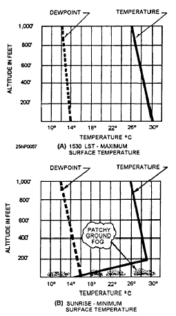
Figure 5-15.-Nocturnal cooling over a land area producing patchy ground fog (calm winds). (A) 1530 Local maximum surface temperature; (B) sunrise-minimum surface temperature.nights versus short days in fall and winter are favorable for the formation of radiation fog.This information is now available on CD in Adobe PDF Printable Format |
|
Privacy Statement - Press Release - Copyright Information. - Contact Us - Support Integrated Publishing |