Custom Search
|
|
 
|
||
|
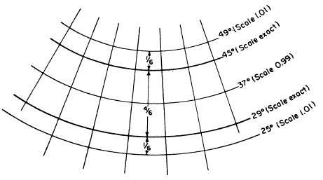
LAMBERT CONFORMAL CONIC PROJECTION The Lambert conformal conic projection attains such a near approach to both directional and distance conformality as to justify its being called a conformal projection. It is conic, rather than polyconic, because only a single cone is used, as shown in figure 9-25. Instead of being considered tangent to the earths surface, however, the cone is considered as penetrating the earth along one standard parallel and emerging along another. Direction is the same at any point on the map, and the distance scale at a particular point is the same in all
Figure 9-26.-distortion of the Lambert conformal conic projection with the standard parallels at 29 degrees and 45 degrees. directions. However, the distance scale that applies to the whole map is exact only at the standard parallels, as shown in figure 9-26. Between the parallels the scale is a little too small; beyond them, it is a little too large. The discrepancy is small enough to be ignored in work of ordinary precision or less. For work of higher precision, there are correction factors that may be applied.The Lambert conformal conic projection is the base for the state coordinate systems devised by the Coast and Geodetic Survey for zones of limited north-south dimension and indefinite east-west dimension. For zones whose greater dimension is north-south, the Coast and Geodetic Survey uses the transverse Mercator projection. |
 |
|
|
||