Custom Search
|
|
 
|
||
|
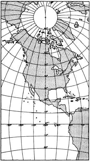
POLYCONIC PROJECTION In polyconic projection a near approach to direction conformality is obtained in relatively small-area maps by projecting the area in question onto more than one cone. A central meridian on the map is straight; all the others are slightly curved and not quite parallel. Similarly, the parallels are slightly curved and not quite parallel; therefore, they are not precisely perpendicular to the meridians. An example of a polyconic map projection is shown in figure 9-24. Polyconic projection is extensively used for the quadrangle maps (familiarly called quad sheets) of areas of the United States published by the Geological Survey. For most of the built-up areas of the States, these maps are available on a scale of 1:24,000,
Figure 9-24.Polyconic projection of North America. showing areas extending for 730 of latitude and longitude. An index map is available, which gives you the quadrangle divisions and the name of the map that covers a particular area.That polyconic projection is not conformal distance-wise is indicated by the fact that one of these quad sheets, though it shows an area that is square on the ground, is oblong rather than square. The vertical or latitudinal length of the map is always greater than the horizontal or longitudinal length. The reason is that latitude is measured along a meridian, which is always a great circle, while longitude is measured along a parallel; and every parallel other than the equator is less than a great circle.An understanding of the concept of the great circle is essential to a thorough understanding of map and
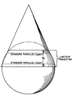
Figure 9-25.-Lambert conformal conic projection. chart projection. A great circle is any line on the earths surface (not necessarily a meridian or the equator) that lies in a plane that passes through the earths center. Any meridian lies in such a plane; so does the equator. But any parallel other than the equator lies in a plane that does not pass through the earths center; therefore, no parallel other than the equator is a great circle.Now, 1 minute of arc measured along a great circle is equal to 1 nautical mile (6076.115 ft) on the ground. But 1 minute of arc measured along a small circle amounts to less than 1 nautical mile on the ground. Therefore, a minute of latitude always represents a nautical mile on the ground, the reason being that latitude is measured along a meridian and every meridian is a great circle. A minute of longitude at the equator represents a nautical mile on the ground because, in this case, the longitude is measured along the equator, the only parallel that is a great circle. But a minute of longitude in any other latitude represents less than a nautical mile on the ground; and the higher the latitude, the greater the discrepancy. |
 |
|
|
||