|
||
|
|
||
| |||||||||||||||
|
|
Click here to Order your Radar Equipment Online In addition to the above cloud patterns, visual and infrared imagery permit us to differentiate between major cloud types. Table 10-2-1 lists various cloud types and their appearance as seen in imagery.High and Mid Clouds High and mid clouds are more easily interpreted in IR imagery than in visual imagery. Most
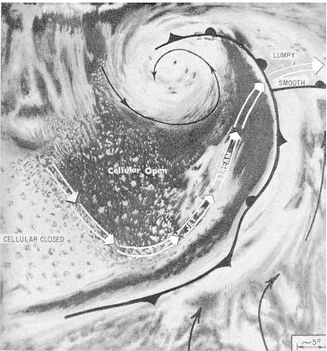
Figure 10-2-3.(A) Open cells in the subtropical high. (B) Closed cells in a subtropical high.
Figure 10-2-4.An idealized illustration showing a jet stream over the dividing line between open and closed cellular clouds. The jet stream east of the upper air trough is shown crossing over an occluded front.
Figure 10-2-5.(A) Enhanced cumulus at A leads to frontal wave development. (B) A well developed comma-shaped cloud, the result of a moving vorticity center to the rear of the polar front. The comma cloud is composed of middle and high clouds over the lower-level cumulus and is preceded by a clear slot.Table 10-2-1.Appearance of
Clouds in Satellite Pictures
of the clouds appear uniformly white in This all stems from the fact that the radio-meter senses a combination of radiated electro-magnetic energy-the cloud temperatures radiated from the top of the cirrus layer, and the warmer radiation transmitted upward through the cirrus layer. Thin cirrus is far more susceptible to having its IR readings masked by the radiation emitted by lower, warmer cloud decks. In regions experiencing strong temperature inversions, such as the polar latitudes in winter, cirrus can appear darker than the snow-covered land. This is caused by the radiation emitted from relatively warm clouds within the inversion layer being detected beneath the cirrus layer. The radiometer inte-grates the radiation readings of the cirrus and the warmer, lower cloud deck. The image produced by such occurrences shows the cirrus as a darker shade than the colder snow-covered ground. Care must be exercised when interpreting the imagery over such regions. Cirrus-topped cumulonimbus clouds are among the brightest clouds seen in visual and IR imagery. Figure 10-2-6 shows the dense cirrus associated with thunderstorm clusters over Central America and the southeastern North Pacific Ocean. This type cirrus is often referred to as "cirrus blowoff". It has a sharp boundary on the upwind side, while on the downwind side the cirrus is thin and wispy. Satellite imagery shows that most middle clouds are associated with synoptic-scale storms or are within areas in which large numbers of thunderstorms are occurring. In both cases, much of the middle cloudiness occurs beneath higher cirrus or cirrostratus. Middle clouds are observed directly only around the fringes of storms or in small isolated patches. In IR, mid clouds appear as an intermediate shade of gray between the shades assigned to the coldest and warmest clouds detected in a given area. Middle clouds and thin cirrus often take on the same shade of gray, which makes distinguishing between the two cloud types difficult, if not impossible. |
|
Privacy Statement - Press Release - Copyright Information. - Contact Us - Support Integrated Publishing |