|
||
|
|
||
|
Page Title:
Cellular Cloud Patterns-Open and Closed |
||
| |||||||||||||||
|
|
Click here to Order your Radar Equipment Online Cellular Cloud Patterns-Open and Closed These are the most common cloud formations found in satellite pictures. Both patterns are
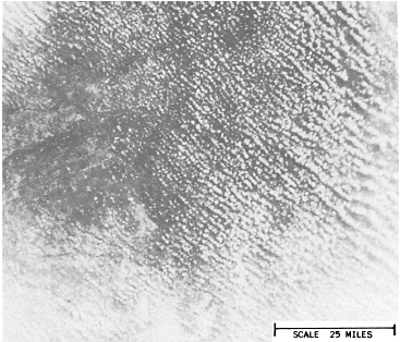
Figure 10-2-1.Cloud
streets.
Figure 10-2-2.Enlarged view. DMSP low enhancement. Convective cloud lines
over land. 1446 GMT 19 June 1975. associated with regions experiencing cold-air advection. Open-celled cumulus form where cold air is advected over warm water (a large air-sea temperature difference). Closed-celled stratocumulus forms in the same manner except the sea-air temperature difference is not as great. As you can see, the cell type is dependent on the heating from below. These patterns also signify the stability of the air over the region. The air is more unstable over regions covered by open-celled cumulus than closed-cell stratocumulus. Figure 10-2-3, views A and B, shows open- and closed-cellular cloud patterns. These patterns not only aid us in identifying regions of cold air advection and cloud types and stability, they also help in locating areas of cyclonic, anticyclonic, and divergent winds, jet streams, and regions of positive voriticity advection. Open-celled cloud patterns are found over areas of cyclonic wind-flow, while closed-cell cloud patterns occur most often over areas experiencing anticyclonic flow. Figure 10-2-4 shows the relationship between open- and closed-cell clouds and the jet stream. The jet lies along the area of transition between the open and closed cells. Areas of maximum positive vorticity advection (PVA MAX) are most commonly observed over the oceans in the fields of open-celled cumulus clouds behind cold fronts. There are two significant cloud patterns associated with the PVA MAX-enhanced cumulus, which is bright cumulus cloud clusters within an area 3 to 5 degrees across, and a bright comma-shaped cloud formation. Figure 10-2-5, views A and B, shows both cloud patterns.Eddies An eddy is a spiral cloud pattern most often produced by disturbances in the wind field caused by terrain features. Low-level wind shear in oceanic high-pressure areas also produces eddies. They show up as swirls of stratus and fog. |
|
Privacy Statement - Press Release - Copyright Information. - Contact Us - Support Integrated Publishing |