| Tweet |

Custom Search
|
|
 
|
||
|
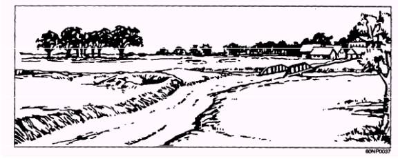
Range Card for a PDF The range card for a PDF is very similar to an FPL range card. The only real difference is the machine gun symbol. A PDF does not align with a sector limit. The following scenario is to illustrate how to prepare a range card for a PDF. Figure 4-22 provides an illustration of a tactical field setting. Figure 4-19.- Panoramic view of tactical area. Figure 4-20.- Beginning of a range card.
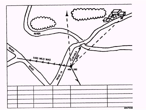
Figure 4-21.- Completed range card. Figure 4-22.- Panoramic view of tactical area. Scenario A machine gun fire team has been attached to the third platoon of Alfa Company. The squad leader and another gun team have become casualties. The platoon is deployed in a tree line overlooking a bridge. The enemy is suspected to have infiltrated the village on the other side of the river. The mission of the platoon is to stop any attempt from the enemy to cross the river via the bridge. The first platoon is to the right of the third platoon, and Bravo Company has joined the third platoon on the left. The commander of the third platoon has informed the machine gun team leader that the machine gun fire team is to be deployed on the left flank of the platoon. The team leader is to get the best angle to fire across the bridge. The team leader informs the machine gun fire team to lay the gun on a PDF centered on the bridge. The lone tree on the immediate right is the right sector limit, and the leftmost edge of the grove of trees across the river is the left sector limit. Using a compass or GPS, the machine gun fire team has located the gun at grid coordinate 468262. The grid is also 350 meters from a road junction that is located on a magnetic back azimuth of 5,420 mils. The PDF lies on a magnetic azimuth of 4,120 mils.
Figure 4-23 shows the beginning stages of the range card. It shows the weapon symbol, the magnetic North arrow, the magnetic orientation line and location grid coordinates, the sector limits, and the PDF.
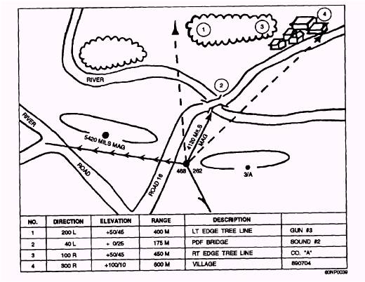
Figure 4-24 shows the completed range card. Details have been added, such as the unit identification block, the terrain features, the location of friendly troops or equipment, and the targets with their individual data.
|
||
|
||