Custom Search
|
|
 
|
||
|
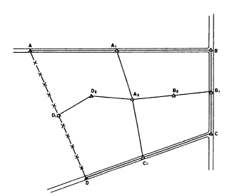
CHAPTER 8 TOPOGRAPHIC SURVEYING AND MAPPING Topography refers to the characteristics of the land surface. These characteristics include relief, natural features, and artificial (or man-made) features. Relief is the conjuration of the earths surface and includes such features as hills, valleys, plains, summits, depressions, and other natural features, such as trees, streams, and lakes. Man-made features are highways, bridges, dams, wharfs, buildings, and so forth. A graphic representation of the topography of an area is called a topographic map. A topographic map is simply a drawing that shows the natural and artificial features of an area. A topographic survey is a survey conducted to obtain the data needed for the preparation of a topographic map. This data consists of the horizontal and vertical locations of the features to be shown on the map.In this chapter and the following chapter, you will study methods and procedures used to perform topographic surveying and to prepare topographic maps. TOPOGRAPHIC SURVEYING The fieldwork in a topographic survey consists principally of (1) the establishment of a basic frame-work of horizontally and vertically located control points (called instrument points or stations) and (2) the determination of the horizontal and vertical locations of details in the vicinity of each instrument point. We will begin our discussions with topographic control. TOPOGRAPHIC CONTROL Topographic control consists of two parts: (1) horizontal control, which locates the horizontally fixed position of specified control points, and (2) vertical control, in which the elevations of specified bench marks are established. This control provides the framework from which topographic details, such as roads, buildings, rivers, and the elevation of ground points, are located. Horizontal Control Locating primary and secondary horizontal control points or stations may be accomplished by traversing, by triangulation (discussed in part 2 of this TRAMAN), or by the combined use of both methods. On an important, large-area survey, there may be both primary control, in which a number of widely separated primary control points are located with a high degree of precision; and secondary control, in which stations are located with less precision within the framework of the primary control points. The routing of a primary traverse should be considered carefully. It should follow routes that will produce conveniently located stations. Such routes might run along roads, ridges, valleys, edges of wooded areas, public land lines, or near the perimeter of tracts of land. This latter route is of particular importance for small areas. When all the details in the area can be conveniently located from stations on the primary traverse, you do not need secondary traverses. However the size or character of the terrain or both usually make secondary traverses necessary. Consider, for example, the situation shown in figure 8-1. This figure shows a tract bounded on three sides by highways and on the fourth side by a fence. For simplification, the figure shows only the items to be discussed. An actual complete plan would include a title, date, scale, north arrow, and so forth.
Figure 8-1.-Primary traverse and secondary traverse. The primary traverse ABCD runs around the perimeter of the tract. Were this tract sufficiently small and level, then details within the whole tract could be located from only the primary control points; that is, from stations A, A1, B, B1, C, C1, D, and D1. In this case, however, the size (or perhaps the character) of the terrain made it necessary to establish additional control points within the perimeter of the tract, such as D2, A2, and B2. These stations were established by running traverse lines (called crossties) across the area from one primary traverse station to another. It should be noted that, since each secondary traverse closes on a primary control point, errors cannot accumulate any farther than the distance between the primary stations.Field notes for the survey sketched in figure 8-1 must contain (1) notes showing the horizontal locations of the stations and (2) level notes for determining the elevations of the stations. Vertical Control In topographic surveying, bench marks serve as starting and closing points for the leveling operations when you are locating details. Although for some surveys the datum may be assumed, it is preferable that all elevations be tied to bench marks which are referred to the sea-level datum. In many areas, particularly in the United States, series of permanent and precisely established bench marks are available. As a surveyor, you must make every feasible effort to tie in your surveys to these bench marks to ensure proper location and identification. Often, the established horizontal control marks are used as the bench marks because the level routes generally follow the traverse lines. Vertical control is usually carried out by direct leveling; however, trigonometric leveling may be used for a limited area or in rough terrain. When you establish the primary vertical control to use in a topographic survey for an intermediate-scale map, four degrees of precision are used as follows: 1. 0.05 foot2. 0.1 foot3. 0.3 foot4. 0.5 footYou use the third or fourth orders of precision for a large-scale map that generally has a contour interval of 1 or 2 feet. For an extensive survey of a large area, use the third order; for surveys of a smaller area, use the fourth order. Once the topographic control has been established, your next major step in a topographic survey is to locate the details horizontally and vertically in the vicinity of each control point or station. These details consist of (1) all natural or artificial features that will appear on the map and (2) enough ground points and spot elevations to make the drawing of contour lines possible. The methods and the instruments used in topographic surveys depend upon the purpose of the survey, the degree of precision needed, the nature of the terrain to be covered, the map scale, and the contour interval. For a high degree of accuracy, you should locate azimuths with a theodolite or transit. Measure horizontal distances with the chain or the electronic distance measurement (EDM) device. Determine elevations with a level. The following sections discuss two methods that are commonly used to locate topographic details. A third method (topography by plane table) is discussed in the next chapter of this TRAMAN |
 |
|
|
||