Custom Search
|
|
 
|
||
|
Traverse Tables/Adjusting Bearings and
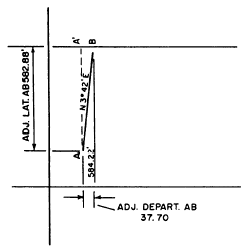
Distances In computing latitudes and departures, your arithmetical calculations can be greatly expedited by the use of a traverse table, in which latitudes and departures for any bearing and distance can be determined mostly by looking for them in the table. Figure 7-15 shows sample pages from a table that gives angle-of-bearing values to the nearest quarter-degree (15'). More precise tables give angular values to the nearest 01'. Under each of the bearing values at the head of the page, a double column gives latitudes and departures for distances of from 1 to 100 feet. For a particular traverse line, you determine the latitudes and departures by breaking down the distance, moving decimal points, and adding up results as in the following example:Suppose you want to determine the latitude and departure for a traverse line 725.32 feet long, bearing N1530'E. To get the latitude, do it as follows. In the latitude column under 15 1/2, lookup the latitude for 70 feet. You read 67.45 feet. If the latitude for 70 feet is 67.45 feet, the latitude for 700 feet is 674.50 feet. Note this in your notes.Next, you look up the latitude for 25 feet under the same 15 1/2 latitude column, which is 24.09 feet. The latitude for 725 feet, then, is 674.50+ 24.09= 698.59 feet. Finally, for the 0.32 foot, look up the latitude for 32 feet, which is 30.84 feet. If the latitude for 32 feet is 30.84 feet, the latitude for 0.32 foot must be 0.3084 fret, which rounds off at 0.31 foot. The numerical value of the latitude then is 698.59 + 0.31 = 698.90 feet. Because the line AB bears northeast, the latitude is positive. You get the departure in the same way by using the departure column. Finally, you enter the adjusted latitudes and adjusted departures in the last two columns. Determine the values in each case by applying the correction to the original latitude or departure. Note that the negative latitudes now equal the positive latitudes and the negative departures equal the positive departures. This indicates that the errors of closure have been entirely distributed. With the adjusted latitudes and departures, you can now adjust the original bearings and distances by the method called inversing. Inversing simply means computing the bearing and length of a traverse line from the latitude and departure. Again the process is one of simple triangle solution. Figure 7-16 shows traverse line AB with the adjusted latitude and departure noted. To determine the adjusted angle of bearing, you solve the triangle AA'B for angle A'AB as follows:
The adjusted bearing of AB, then, is N342'E. For the adjusted distance, solve the triangle for AB as follows:
Figure 7-16.Adjusted bearing and distance from adjusted latitude and departure.The adjusted length of AB, then, is 584.22 feet.
Plane Coordinates The location of a point by plane coordinates means to describe the location of the point in terms of its distance north or south and east or west from a point of origin.Figure 7-17 shows how coordinate distances are measured on an axis (called the Y axis) running north to south through the point of origin. East to west coordinates are measured on an X axis running east to west through the point of origin. Values on the Y axis north of the point of origin are plus; values south of the point of origin are minus. Values on the X axis east of the point of origin are plus; values west of the point of origin are minus. PLANE COORDINATES FROM LATITUDE AND DEPARTURE. Figure 7-17 also shows the relationship between the plane coordinates of the end stations on a traverse line and the latitude and departure of the line. You can see that the difference between the Y coordinate of A and the Y coordinate of B (which is 200.00 feet) equals the latitude of AB. Also, you can see that the difference between the X coordinate of A and the X coordinate of B (which is 600.00 feet) equals the departure of AB. Therefore, if you know the coordinates of one of the stations in a traverse, you can determine the coordinates of the others from the latitudes and
Figure 7-17.Location by plane coordinates.
Figure 7-18.Closed traverse with adjusted latitudes and departures.departures. Figure 7-18 shows a closed traverse with adjusted latitudes and departures notes. You want to assign plane coordinates to the traverse stations. To avoid the necessity of working with negative coordinates, you select as point of origin a point O that is west of the most westerly traverse station and south of the most southerly traverse station.You determine the bearing and length of dotted line OD and compute from these values the latitude and departure of OD. You can see that the Y coordinate of station D must equal the latitude of OD, or 150.70 feet Also the X coordinate of D must equal the departure of OD or 556.30 feet.The Y coordinate of station A equals the Y coordinate of D plus the latitude of AD or150.70 + 591.64 = 742.34 ft.The X coordinate of station A equals the X coordinate of D minus the departure of AD or556.30 523.62 = 32.68 ft.The Y coordinate of station B equals the Y coordinate of station A plus the latitude of AB or742.34 + 255.96 = 998.30 ft.The X coordinate of station B equals the X coordinate of station A plus the departure of AB or32.68 + 125.66 = 158.34 ft.The Y coordinate of station C equals the Y coordinate of station B minus the latitude of C or998.30 153.53 = 844.77 ft.The X coordinate of station C equals the X coordinate of station B plus the departure of BC or158.34 + 590.65 = 748.99 ft.The Y coordinate of station D equals the Y coordinate of station C minus the latitude of CD or844.77 694.07 = 150.70 ft.The X coordinate of station D equals the X coordinate of station C minus the departure of CD or748.99 192.69 = 556.30 ft.These are the same coordinates you originally computed for station D, a fact that serves as a check on your accuracy.You enter these values on a form that is similar to the one shown in figure 7-19. In actual practice, however, you will use a wider form on which all values and computations from the original station through bearing and distance, latitude and departure, and coordinates can be entered. |
||
|
||