Custom Search
|
|
 
|
||
|
TRIGONOMETRIC LEVELING When you know the vertical angle and either the horizontal or slope distance between two points, you can apply the fundamentals of trigonometry to calculate the difference in elevation between the points. That is the basic principle of trigonometric leveling. This method of indirect leveling is particularly adaptable to rough, uneven terrain where direct leveling methods are impracticable or too time consuming. As in any survey, the equipment that you will use in trigonometric leveling depends on the precision required. For most trigonometric-leveling surveys of ordinary precision, angles are measured with a transit, or alidade, and distances are measured either with a tape or by stadia, which you will study in chapter 8. On reconnaissance surveys the vertical angles may be measured with a clinometer, and distances maybe obtained by pacing. The method used in trigonometric leveling is described in the following paragraphs:
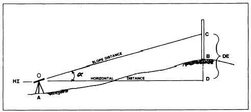
Figure 7-2.Difference in elevation in trigonometry leveling.
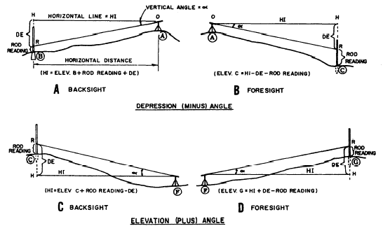
Figure 7-3.Lines of indirect levels. In figure 7-2, a transit is setup and leveled at A. The rodman holds a rod on B. The instrumentman trains the telescope on C, which is an easily read value (usually a full foot) on the rod. With the telescope trained on C, the vertical angle (a) is read. Then either the horizontal distance or the slope distance between the instrument and rod is determined. Now one side and one angle of a right triangle (OCD) are known. From your knowledge of trigonometry, you know that the other sides and angle can be computed. However, in trigonometric leveling, you are concerned only with determining the length of the side opposite the measured angle (side CD). The length of this side is the difference in elevation (DE). As-you can see in figure between the height of7-2, the DE is the distance instrument (HI) and the intersection of your line of sight with the rod (point C). Computing the DE consists of multiplying the measured distance by the proper trigonometric function of the measured angle (sine, when slope distance (OC) is measured; tangent, when horizontal distance (OD) is measured).The following paragraphs discuss typical situations that you will encounter in trigonometric leveling. You will see in each of these situations the reamer in which the computed DE is applied to determine the HI and required elevations. 1. DEPRESSION ANGLE BACKSIGHT (fig. 7-3, view A). The rod is on point B below the instrumerit. The measured vertical angle (a) is a depression (minus) angle. To compute the HI, the rod reading RB and the DE are added to the elevation of B, orHI = RB + DE + Elev. B. 2. DEPRESSION ANGLE FORESIGHT (fig, 7-3, view B). The rod is below the instrument, and the vertical angle is minus. The elevation at C equals the HI minus the DE and minus the rod reading RC, orElev. C = HI DE RC.3. ELEVATION ANGLE BACKSIGHT (fig. 7-3, view C). The rod is above the instrument, and the vertical angle is plus. The HI at F equals the elevation at C plus the rod reading (RC) and minus the DE, orHI = Elev. C + RC DE. 4. ELEVATION ANGLE FORESIGHT (fig. 7-3, view D). The rod is above the instrument and the angle is plus. The elevation of G equals the HI plus the DE and minus the rod reading (RG), orElev. G = HI + DE RG.As mentioned earlier in this section, the horizontal or slope distances used for calculating the DE may be obtained using various methods. For each method, there are requirements and limitations that must be adhered to. These requirements and limitations are discussed as follows:1. Measured distances obtained by horizontal chaining should be corrected for standard error, temperature, and sag before you compute the DE. These corrections are discussed in chapter 12 of the EA3 TRAMAN. Under ordinary circumstances in the Seabees, corrections for earth curvature and refraction are not necessary. However, methods to perform these corrections can be found in commercial publications, such as Surveying Theory and Practice, by Davis, Foote, Anderson, and Mikhail.2. Measured distances obtained by slope chaining also should be corrected as discussed above. In addition, you must convert the slope distance to a horizontal distance before computing the DE. As an aid in computations, tables have been developed that provide the following data:a. Inclination corrections for 100-foot tape b. Differences in elevation forgiven horizontal distances and gradients from 0 to 45c. Differences in elevation for given slope distances and gradients from 0 to 45 d. Horizontal distances for given slope distances and gradients from 0 to 45 3. When using stadia, you should refer to the stadia procedures and formulas described in chapter 8 of this TRAMAN. With practice, stadia provides a rapid means of determining the horizontal distances and elevations. 4. Electronic distance-measuring devices measure the straight-line horizontal or slope distance between instruments. When you use the same setup for slopes, replace the electronic equipment with a theodolite and either a target or a rod to measure the vertical angle. The measured vertical angle can be used to convert the measured slope distance to DE by multiplying by the sine of the vertical angle. |
||
|
||