Custom Search
|
|
 
|
||
|
Cross-Section Leveling In profile leveling, you determine the elevations of a series of points lengthwise along a highway. In cross-section leveling, you determine the elevations of points on a succession of lines running at right angles to the lengthwise line of the highway. The principal purpose of profile leveling is to provide data from which the depth of fill or cut required to bring the existing surface up to, or down to, the grade elevation required for the highway can be determined. Note that profile leveling provides this data relative to the center line. In figure 14-16, you can see along the top the depth of cut or fill required at each station to bring the existing surface to gradethe prescribed grade line for the highway is indicated by the smoothly curved grade line shown. At each station, you can determine the cut or fill by counting the squares between the profile and the grade line.The cross-section lines are established at regular stations, at any plus stations, and at intermediate breaks in the ground. Short cross-lines are laid out by eye, but long crosslines are laid out at a 90 angle to the center line with the transit. For short crosslines, most surveyors prefer to use an angle prism for sighting 900 angles from the center line. Figure 14-18 shows a surveyor using an angle prism for sighting a 900 angle from the center line of the highway.For cross-section leveling, strip topography, and some other purposes, it is necessary to lay off a 900 angle at numerous points along a line. This 900 angle can often be established by
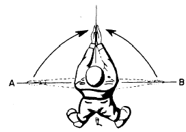
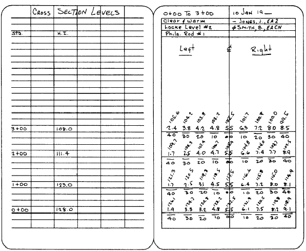
Figure 14-19.-Laying off a 90 0 angle from the center-line stakes.estimation with sufficient accuracy for the particular job. The surveyor straddles the point on the line, arms extended sideward along the marked line (fig. 14- 19). By looking alternately right then left, he adjusts the position of his feet until his body is in line with AB. He then brings his hands together in front of him, thus pointing along an approximate 900 line from the marked line. An experienced surveyor can lay off a 900 angle by this method so that a point 100 ft away will be within 1 ft of the true perpendicular. You should measure all elevations at abrupt changes or breaks in the ground with a rod and level. Measure all distances from the center line with a metallic tape. In rough country, the hand level can be used to advantage for obtaining cross sections if the center-line elevations have been determined by use of the engineers level. Cross-section leveling is usually done with a hand level after the profile run has been made.The method is as follows: From the profile run, you know the center-line elevation at each station. Suppose you want to take cross-section elevations at 10 ft intervals for 40 ft on either side of the center line. The first thing you do is to determine the vertical distance from the ground to your line of sight through the hand level when you stand erect with the level at your eye. The best way to do this is to sight on a level rod held plumb in front of you. Suppose you find that the vertical distance is 5.5 ft. Then your HI at any center-line station is the center-line elevation (obtained in the profile level run) plus 5.5 ft. Suppose that you are standing at station 0 + 00, figure 14-16. The elevation of this station is 122.53 ft. Your HI is therefore .122.53 + 5.5 = 128.03 ft. You round off cross-section elevations to the nearest 0.1 ft. If a rodman holds a rod 40 ft to the left of the center line at station 0 + 00 and you read 1.9 ft on the rod, then the elevation of the point plumbed by the rod is 128.0 1.9 = 126.1 ft. The rodman now moves on to a point 30 ft from the center line. If you read 3.3 ft on the rod, the elevation of this point is 128.0 3.3 = 124.7 ft. Going on in this manner, you determine the elevations at all the required points on the cross section. You then move to the next station and repeat the process. Cross section notes are recorded in the field book by using one of two basic methods. In the first, and often preferred, method, begin at the bottom of the page and read upward, as shown in figure 14-20. This method helps to keep you oriented in the direction in which the line runs and helps to prevent confusion as to which is the right or left side of the line. It therefore reduces the possibility of recording your readings on the wrong side of the center line. In the second method, the notes are recorded in the conventional manner of reading from top to bottom of the page. Whichever method you use, you must remember that as you stand facing the direction in which the line runs, left
Figure 14-20.-Sample field notes from cross-section leveling at first three stations shown in figure 14-7. and right in the notebook must correspond to left and right in the field.Figure 14-20 shows field notes for cross-section levels taken on the first three stations shown in figures 14-16 and 14-17. On the data side, only the station and the HI need to be listed. On the remarks side, each entry consists of a point elevation, written over the distance of the point from the center line. The computed elevation, determined by subtracting the rod reading from the HI, is written in above as shown. Note that the rod reading at the center line is the 5.5-ft vertical distance from your line of sight to the ground. Also, notice that the center-line elevation written in at each station. is the one obtained in the profile level run. You obtain the HI for each station by simply adding together these two figures. |
||
|
||