Custom Search
|
|
 
|
||
|
Profile Leveling In surveying, a PROFILE is a vertical section of the earth measured along a predetermined or fixed line. In practice, profiles are a series of ground elevations determined by differential leveling or other methods that, when plotted along
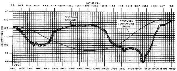
Figure 14-16.-Plotted profile and grade lines along a proposed road center line.
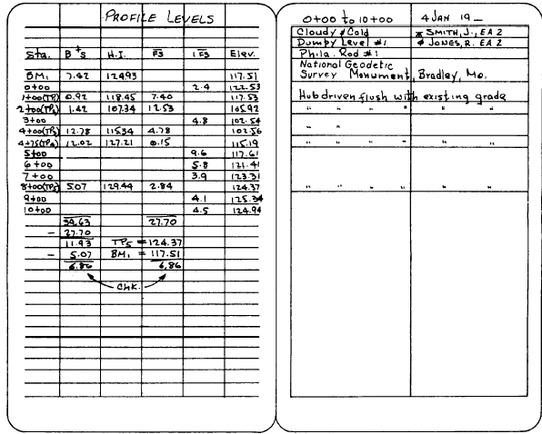
Figure 14-17.-Field notes for profile levels shown in figure 14-7. some line, such as the center line of a road, can be used to determine the final grade or alignment of that road, railroad, or sewer line. Profiles are also used to compute volumes of earthwork. Figure 14-16 shows a plotted profile of the existing ground surface along a proposed highway center line. Horizontally on the graph, you read a succession of 100-ft stations, from 0 + 00 to 19 + 00. Vertically, you read elevations. Note that, horizontally, the interval between adjacent vertical grid lines represents 25 ft; but vertically the interval between adjacent horizontal grid lines represents 2.5 ft.The profile was plotted through a succession of points, each of which was obtained from a profile elevation taken on the ground. Figure 14-17 shows field notes for the levels taken from 0 + 00 through 10 + 00. The level was first set up at a point about equidistant from station 0 + 00 and from a BM identified as National Geodetic Survey Monument, Bradley, Missouri. The elevation of the BM was 117.51 ft. The first backsight reading on a rod held on the BM was 7.42 ft. The height of instrument (HI) was therefore117.51 + 7.42 = 124.93 ft. You can see this entered in the "HI" column. From the first instrument setup, FSs were taken on station 0 + 00 and 1 + 00. The elevation of the station in each case was determined by subtracting the FS reading from the HI. Note that the FS taken on station 1 + 00 is entered in a column headed "FS, " while the one taken on station 0 + 00 is entered in a different column, headed "IFS." " IFS" means intermediate FS, or an FS taken on a point that is neither a BM nor a TP, You can see that station 1 + 00 was used as a TP in shifting the instrument ahead. Only FSS taken on BMs or TPs are entered in the column headed "FS."After an FS was taken on station 1 + 00, it became necessary to shift the instrument ahead. Station 1 + 00 was used as the TP. From the new instrument setup, a BS was taken on a rod held on 1 + 00. The new HI was found by adding the BS reading to the previously determined elevation of 1 + 00.From the new setup, an FS was taken on station 2 + 00; again, the elevation was found by subtracting the FS reading from the HI. After this sight was taken, the instrument was again shifted ahead, probably because of the steepness of the slope. This time, station 2 + 00 was used as the TP2. From the new setup, a BS was taken on station 2 + 00 and a new HI established. From this setup, it was possible to take FSs on both station 3 + 00 and station 4 + 00. Because station 3 + 00 was not used as a TP, the FS on it was entered under IFS.Apparently, the slope between station 4 + 00 and station 5 + 00 was so steep that sighting both stations from the same setup with the rod being used was impossible. Consequently, an inter-mediate TP (TP4) was established at station 4 + 75 by determining the elevation of this station. The instrument was shifted to a setup from which a BS could be obtained on a rod held on this station and from which FSs on stations 5 + 00, 6 + 00, 7 + 00, and 8 + 00 could be taken, Station 8 + 00 was then used as a TP for the last shift ahead. From this last setup, it was possible to take FSs on stations 9 + 00 and 10 + 00. As a check on the arithmetic, you customarily check each page of level notes to check the difference between the sum of the FSs and the sum of the BSs against the difference in elevation between the initial BM or TP and final BM or TP. Obviously, only the BSs and FSs taken on BMs and TPs are relevant to this check, This is the reason why intermediate FSS not taken on BMs or TPs are entered in a separate column.If the arithmetic is correct, the two differences will be the same. As you can see, the sum of the relevant BSs in figure 14-17 is 39.63; the sum of the FSs is 27.70; and the difference between the two is 11.93. Note that from this difference, the BS taken on TP5 is deducted. The reason is the fact that this BS is not offset by a corresponding FS on a BM or TP. With the BS taken on TP5 deducted, the difference between the sum of the FSs and the sum of the BSs is 6.86. The difference between the elevation of TP5 and the elevation of the initial BM is 6.86, so the arithmetic checks. Remember that this procedure provides a check on the arithmetic only. If you have recorded any incorrect values, the arithmetic will check out just as well as when you have recorded the correct values. The procedure is valuable, however, for detecting two mistakes commonly made by beginners. These are subtracting a BS from, instead of adding it to, a BM elevation to get the HI; and adding an FS to, instead of subtracting it from, the HI to get an elevation.
Figure 14-18.Using angle prism for sighting 90 from the center-line stakes. |
||
|
||