|
||
|
|
||
|
Page Title:
Distribution of Icing in the Atmosphere |
||
| |||||||||||||||
|
|
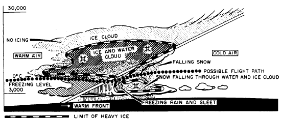
Distribution of Icing in the Atmosphere The atmospheric distribution of potential icing zones is mainly a function of temperature and cloud structure. These factors, in turn, vary with altitude, synoptic situation, orography (physical geography of mountain ranges), location, and season.ICING AND TEMPERATURE. Aircraft icing is generally limited to the layer of the atmosphere lying between the freezing level and the 40C isotherm. However, icing has occasionally been reported at temperatures colder than 40C in the upper parts of cumulonimbus and other clouds. In general, the frequency of icing decreases rapidly with decreasing tempera-ture, becoming rare at temperatures below 30C. The normal vertical temperature profile is such that icing is usually restricted to the lower 30,000 feet of the troposphere. The types of icing generally associated with temperature, and their ranges, are (1) clear, 0C to 10C; (2) a mixture of clear and rime, -10C to 15C; and (3) rime, 15C to 20C, with possible rime occurring at lower temperatures.ICING IN RELATION TO CLOUD TYPE. Stable air masses often produce stratus-type clouds, with extensive areas of relatively continuous icing conditions. Unstable air masses generally produce cumulus clouds, with a limited horizontal extent of icing conditions, where the pilot can expect the icing to become more severe at higher altitudes in the clouds. The type and amount of icing will vary considerably with each type of cloud.Stratiform Clouds. Icing in middle- and low-level stratiform clouds is confined, on the average, to a layer between 3,000 and 4,000 feet thick. However, pilots frequently encounter situations where multiple layers of clouds are so close together that visual navigation between layers is not feasible. In such cases, the maximum depth of continuous icing conditions rarely exceeds 6,000 feet. The intensity of icing generally ranges from light to moderate, with maximum values occurring in the upper portions of the cloud. Both rime and mixed icing are observed in stratiform clouds. The main hazard lies in the great horizontal extent of some of these cloud decks. High-level stratiform clouds are composed mostly of ice crystals and give little icing.Cumuliform Clouds. The zone of probable icing in cumuliform clouds is smaller horizontally but greater vertically than in stratiform clouds. Icing is more variable in cumuliform clouds because many factors conducive to icing depend greatly on the stage of development of the cloud. Icing intensities may range from generally light in small supercooled cumulus to moderate or severe in cumulus congestus and cumulonimbus. The most severe icing occurs in cumulus congestus clouds just before their change to cumulonimbus. Although icing occurs at all levels above the freezing level in a building cumulus, it is most intense in the upper half of the cloud. In a mature cumulonimbus, icing is generally restricted to the updraft regions; and in a dissipating thunder-storm, to a shallow layer near the freezing level. Icing in these types of clouds is usually clear or mixed.Cirroform Clouds. Aircraft icing rarely occurs in cirrus clouds, although some cirrus do contain a small proportion of water droplets. Icing of moderate intensity, however, has been reported in dense cirrus and the anvil-tops of cumulonimbus, where updrafts may maintain considerable water at rather low temperatures.ICING IN FRONTAL ZONES. About 85 percent of all icing conditions reported is associated with frontal zones. Therefore, Aerog-raphers Mates should have a thorough knowledge of the danger areas in the frontal zones so that pilots may be properly briefed. The basic approach to forecasting icing in frontal zones is to relate the front to the cloud types in them. The stratified cloud system associated with the lifting of warm, moist air over a warm front often reaches dangerous subzero temperatures, where rime or glaze icing will occur. If the warm air mass is conditionally unstable, cumuliform clouds may form. These clouds are favorable to the formation of glaze or rime or a combination of both. Figure 6-1-1 shows a typical warm-front structure, with the most probable icing zones and a possible flightpath to minimize exposure to icing. The cloud system of a warm front is extensive, and since a flight through such a system is a long one, the icing dangers are therefore increased.Cumuliform clouds are associated with cold fronts. Glaze and mixed icing can be expected in them. The cloud systems are usually relatively narrow as compared with those of a warm front; therefore, the time spent flying through them is shorter. But because of the heavy precipitation, icing can be rapid and extremely dangerous even though it is of short duration. Figure 6-1-1.-Warm-front icing condition. Figure 6-1-2 illustrates a typical cold-front icing situation. Occluded fronts present less of an icing hazard, because precipitation has been occurring for some time and the cloud system contains less water. Since the cloud system is extensive, however, accumulation may be dangerous. OROGRAPHIC INFLUENCES. The lift-ing of conditionally unstable air over mountain ranges is one of the most serious ice-producing processes experienced in the United States. When mT air moves northward and eastward over the Appalachian Mountains, it is often cooled to sub-freezing temperatures. An icing hazard exists for all air traffic that must travel through that air. Similarly, in winter, maritime polar (mP) air approaching the west coast of the United States contains considerable moisture in its lower levels. As it is forced aloft by the successive mountain ranges encountered in its eastward movement, severe icing zones develop. The movement of a front across a mountain brings together two important factors that aid in the formation of icing zones. A study of icing in the Western United States has shown that almost all cases, the ice occurred where the air was blow-ing over a mountain slope or up a frontal surface or both. The most severe icing zones over mountains will be above the crests and slightly to the wind-ward side of the ridges. The icing zones usually extend about 4,000 feet above the tops of the mountains. In the case of unstable air, they may extend higher. Learning Objective: Identify the cause of turbulence, how it is classified, and where it is most likely to occur. TURBULENCE Turbulence in the atmosphere is rapidly becoming the only weather element that cannot be partially overcome by mechanical devices. Therefore, turbulence is of major importance to all pilots and also to Aerographers Mates whose duty is to recognize situations where turbulence may exist and to forecast for flight operations both the probable areas and the intensity of turbulence. In this chapter, we cover the causative factors, classifications, and locations of turbulence. |
|
Privacy Statement - Press Release - Copyright Information. - Contact Us - Support Integrated Publishing |