|
||
|
|
||
| |||||||||||||||
|
|
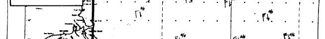
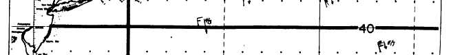
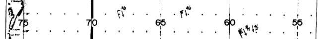
Analysis Procedures As with any chart analysis, you should review past history, especially the most recent analysis. The most recent analysis is of primary impor-tance, because waves are not very conservative. Sea heights are subject to significant change over relatively short periods of time. The most recent analysis gives you an idea of what to look for on the current chart. I recommend transferring the highest labeled sea-height contours (high sea areas) onto the current chart and beginning your analysis in one of these areas.Another aid in analyzing sea heights is the current and past sea-level pressure (surface) charts. Because most waves are wind generated, the wind directions, speeds, fetch, and duration are elements that will help you with your analysis. These elements are either plotted on the surface chart or can be determined from the plotted data. The sea-height analysis consists of contours drawn at 3-foot intervals, i.e., 3, 6, 9, 12. Much like isobaric analysis, you connect the reports of equal sea heights. Scan the chart for reports that provide a continuous closed contour. In the high sea areas, you might begin with a 9-foot contour. Connecting points of equal sea heights seems easy; however, a proper analysis calls for far more than connecting a series of like sea-heights. For example, a single contour may outline hundreds or thousands of square miles based on the reported heights but be incorrect. The reason the contour could be wrong can often be attributed to the analyst not taking into account wind and wave directions. A proper analysis requires that you check the wind and wave directions, as well as the heights.
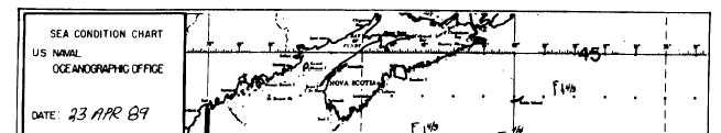
Figure 1-4-1.-Plotted sea condition chart. Along coasts, the height of wind waves is controlled by the wind velocity (speed and direction), and bottom topography. If the wind is blowing onshore and is quite strong, the inner-most sea-height contour might be quite high. With an offshore wind, the innermost contour will be small, usually 0 or 3. When the wind blows parallel to the shore, the sea heights may be large or small, depending on the speed and duration of the wind.All sea heights near the shores of continents and large islands are influenced by land and sea breezes. Modification of the existing wind field by these breezes can increase or decrease sea heights. Also, strong gravity winds that form when cold dense continental air flows down from atop continental highlands produce high waves for short distances from shore.Another factor affecting wave height is water depth. Shallow water, water that has a depth that is less than one-half the length of the waves passing over it, slows the waves and increases their height.In the open sea, the height and direction of the sea is, for the most part, directly related to the wind. Where waves move with a current, the wavelengths increase and the heights lessen. The opposite holds true when seas oppose a current. In areas where strong currents oppose one another, waves can steepen even to the point of breaking. The North Wall of the Gulf Stream, where the Gulf Stream meets the Labrador Current, is one such area. Sea-height contours are drawn in the form of closed loops or continuous lines that begin and end along a coast. The closed contours delineate maximum or minimum sea areas. See figure 1-4-2.
|
|
Privacy Statement - Press Release - Copyright Information. - Contact Us - Support Integrated Publishing |