 |
||
|
|
||
|
Page Title:
Forecasting turbulence near the surface |
||
| |||||||||||||||
|
|
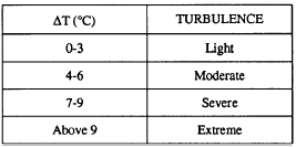
Click here to Order your Radar Equipment Online FORECASTING TURBULENCE NEAR THE SURFACEOver land during nighttime hours there is very little turbulence near the surface. The only exception is that of high wind speeds over rough terrain. This type of turbulence decreases with increasing height.During the daylight hours, turbulence near the surface depends on the radiation intensity, the lapse rate, and the wind speed. Turbulence intensity tends to increase with height throughout the unstable and neutral layers above the surface to the first inversion, or stable layer. Similar turbulence occurs in fresh polar outbreaks over warm waters.Vertical gustiness increases with height more rapidly than horizontal gustiness.Situations for violent turbulence near the surface occur shortly after a cold frontal passage, especially over rough terrain. Other examples of turbulence occur over deserts on hot days and during thunderstorms. Peak gusts at the surface can be estimated to be essentially equal to the wind speeds at the gradient level, except in thunderstorms.FORECASTING TURBULENCE IN CONVECTIVE CLOUDSIn the absence of any dynamic influences that might serve to drastically modify the vertical temperature and moisture distribution, on-hand rawinsonde data maybe used to evaluate the turbulence potential of convective clouds or thunderstorms for periods up to 24 hours. The following is one procedure for predicting turbulence in such clouds. This method is often referred to as the Eastern Airlines Method:The technique is as follows: . Determine the CCL. . From the CCL, proceed along the moist adiabat to the 400-hPa level. This curve is referred to as the updraft curve.. Compare the departure of the updraft curve with the free air temperature (T) curve at the 400-hPa level.For positive values, the updraft curve should be warmer than the (T) curve. That is, the updraft curve would be to the right of the (T) curve. The value of the maximum positive departure obtained in this step is referred to as AT.Table 5-3 is based on several years relating AT values to commercial pilot reports of thunderstorm turbulence, and can be used to predict the degree of turbulence in air mass thunderstorms.This method of forecasting thunderstorm turbulence is almost exclusively confined to the warmer months when frontal cyclonic activity is at a minimum. During the cooler months, frontal and cyclonic influences may cause rapid changes in the vertical distribution of temperatures and moisture, and some other methods have to be used.FORECASTING CLEAR AIR TURBULENCE (CAT)Clear air turbulence is one of the more common in-flight hazards encountered by high-altitude, high-performance aircraft.Not all high-level turbulence occurs in clear air. However, a rough, bumpy ride may occur in clear air, without visual warning. This turbulence may be violent enough to disrupt tactical operations, and possibly cause serious airframe stress and/or damage.Most cases of CAT at high altitudes can be attributed to the jetstream, or more specifically, the abrupt vertical wind shear associated with the jetstream. CAT is experienced most frequently during the winter months when the jetstream winds are the strongest.The association of CAT with recognizable synoptic features has become better understood over the last few years. The following are general areas where CAT may occur:. In general, in any region along the jetstream axis where wind shear appears to be strong horizontally, vertically, or both.. In the vicinity of traveling jet maxima, particularly on the cyclonic side.. In the jetstream below and to the south of the core.. Near 35,000 feet in cold, deep troughs. The instruction Atmospheric Turbulence and Icing Criteria, NAVMETOCCOMINST 3140.4, sets forth associated phenomena, as well as a common set of criteria for the reporting of turbulence.
Table 5.3.-Relation of Maximum Positive Departure to Thunderstorm TurbulenceThis information is now available on CD in Adobe PDF Printable Format |
|
Privacy Statement - Press Release - Copyright Information. - Contact Us - Support Integrated Publishing |