 |
||
|
|
||
|
Page Title:
Conditions favorable for ice fog |
||
| |||||||||||||||
|
|
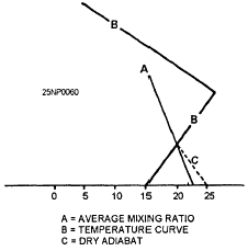
Click here to Order your Radar Equipment Online CONDITIONS FAVORABLE FOR ICE FOG When the air temperature is below about -25F, water vapor in the air that condenses into droplets is quickly converted into ice crystals. A suspension of ice crystals based at the surface is called "ice fog." Ice fog occurs mostly in the Arctic regions, and is mainly an artificial fog produced by human activities, It occurs locally over settlements and airfields where hydrocarbon fuels are burnedthe burning of hydrocarbon fuels produces water vapor.When the air temperature is approximately -30F or lower, ice fog frequently forms very rapidly in the exhaust gases of aircraft, automobiles, or other types of combustion engines.When there is little or no wind, it is possible for an aircraft to generate enough ice fog during landing or takeoff to cover the runway and a portion of the airfield. Depending on the atmospheric conditions, ice fogs may persist for periods of a few minutes to several days. There is also a tine arctic mist of ice crystals that persists as a haze over wide expanses of the arctic basin during winter; this fine mist may extend upward through much of the troposphere, similar to a cirrus cloud with the base reaching the ground.USE OF THE SKEW T LOG P DIAGRAM IN FORECASTING THE FORMATION AND DISSIPATION OF FOGOne of the most accepted methods for forecasting the formation and dissipation of fog makes use of an upper air sounding plotted on the Skew T Log P Diagram. The plotting of an upper air sounding is useful in forecasting both the formation and dissipation of fog, but it can be used more objectively in forecasting fog dissipation.The use of an upper air sounding to determine the possibility of fog formation must be subjective. A study of the existing lapse rate should be made to determine the stability or instability of the lower layers. The surface layer must be stable before fog can form. If it is not found to be stable, the cooling expected during the forecast period must be considered, and this modification should be applied to the sounding to determine if the layer will be stable with the additional cooling.The difference between the temperature and the dewpoint must be considered. If the air temperature and the dewpoint are expected to coincide during the period covered by the forecast, a formation of fog is very likely. The expected wind speed must be considered. If the wind speed is expected to be strong, the cooling will not result in a surface inversion favorable for the formation of fog, but may result in an inversion above the surface, which is favorable for the formation of stratus clouds.DETERMINATION OF FOG HEIGHT An upper air sounding taken during the time fog is present will show a surface inversion. The fog will not necessarily extend to the top of the inversion. If the temperature and dewpoint have the same value at the top of the inversion, you can assume that the fog extends to the top of the inversion. However, if they do not have the same value, you can determine the depth of the fog by averaging the mixing ratio at the surface and the mixing ratio at the top of the inversion. The intersection of this average mixing ratio with the temperature curve is the top of the fog layer.Two methods that may be used to find the height of the top of the fog layer, in feet, are reading the height directly from the pressure-height curve on the Skew T Log P Diagram or by using the dry adiabatic method.1. In using the pressure-height curve method, locate the point where the temperature curve and the average mixing ratio line intersect on the Skew T Log P Diagram. Move this point horizontally until the pressure-height curve is intersected. Determine the height of the fog layer from the value of the pressure-height curve at this intersection.2. The dry adiabatic method is based on the fact that the dry adiabatic lapse rate is 1C per 100 m, or 1C per 328 ft. Using this method, follow the dry adiabat from the intersection of the average mixing ratio line with the temperature curve to the surface level. Find the temperature difference between the point where the dry adiabat reaches the surface and the point of intersection of the dry adiabat and the average mixing ratio. For example, in figure 5-18, the dry adiabat at the surface is 25C. The temperature at the intersection of the dry adiabat and the average mixing ratio is 20C. By applying the dry adiabatic method with a lapse rate of 1C per 328 ft, we find the height of the top of the fog layer as follows:
Figure 5-18.-Dry adiabatic method of determining fog height.
DISSIPATION To determine the surface temperature necessary for the dissipation of fog by using the Skew T Log P Diagram, trace dry adiabatically from the intersection of the average mixing ratio line and the temperature curve to the surface level. The temperature of the dry adiabat at the surface level is the temperature necessary for dissipation. This temperature is known as the CRITICAL TEMPERATURE. This temperature is an approximation, since it assumes no changes will take place in the stratum from the time of observation to the time of dissipation. This temperature should be modified on the basis of local conditions. See figure 5-18. In considering the dissipation of fog and low clouds, you should consider the rate at which the surface temperature will increase after sunrise. Vertically thick fog, or multiple cloud layers, will slow up the morning heating at the surface. If advection fog is present, the fog may be lifted off the ground to a height where it is classified as stratus. If ground fog is present, the increase in surface air temperature will cause the fog particles to evaporate, thus dissipating the fog. Further heating may evaporate advection fog and low clouds. This information is now available on CD in Adobe PDF Printable Format |
|
Privacy Statement - Press Release - Copyright Information. - Contact Us - Support Integrated Publishing |