|
||
|
|
||
| |||||||||||||||
|
|
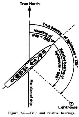
DIRECTION We usually indicate direction from true north. We give directions in degrees, measured clockwise from true north, or 000T. We state courses and bearings in three digits. In other words, 45 degrees is 045 (zero four five). Seldom is it necessary to consider compass direction to a value smaller than a degree, even though each degree contains 60 minutes of 60 seconds each. A true bearing is the direction of an object from the observer, measured clockwise from true north. A relative bearing is the direction of an object measured clockwise from the ship's bow. Objects seen by lookouts are reported in terms of relative bearings by degrees. See figure 3-6. The reciprocal a bearing is its opposite; that is, the point or degree on the opposite side of the compass from the bearing. For example, the reciprocal of 180 is 000. When you obtain a bearing on an object, the bearing from the
object to you is the reciprocal of the bearing from you to it. To fmd the reciprocal of any bearing expressed in degrees less than 150, simply add 180 to the bearing. If the bearing is 050, its reciprocal is 050 plus 180 or 230. If your bearing is greater than 180, subtract 180. In addition to true and relative direction measurement, there are other common references, such as measurement from the magnetic pole and grid reference lines on charts. However, all direction measurement systems are based on the degrees in a circle or points on a compass rose. The Cardinal Point System For centuries, navigators used a system of compass readings, called compass points, to indicate direction. An observer would use the cardinal points of the compass (north, south,
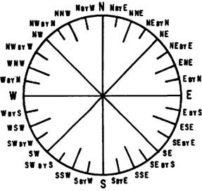
Figure 3-7.-The mariner's cardinal point system. east, and west) and intervening points between each cardinal point to indicate the direction of an object. Figure 3-7 shows the 32 relative bearings by points around a ship. The cardinal point system may be used when a high degree
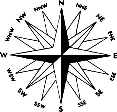
Figure 3-8.-The mariner's cardinal point system. of accuracy is not required. Only the rules of the road and some harbor pilots and coastal merchant mariners still express direction in points. Figure 3-8 shows a compass rose with 16 points of the compass. The Azimuth System The azimuth system measures direction by dividing a circle into 360 equal parts, called degrees, and subdividing each degree into minutes and seconds. We measure direction in degrees, minutes, and seconds clockwise from north in a horizontal plane. Some marine compasses show both the cardinal point and the azimuth figures on their cards. Figure 3-9 shows a compass card with the azimuth system and eight cardinal points superimposed on it. In this figure, the subdivisions of a degree are not shown. For most navigational purposes, subdivisions of a degree are not necessary. |
|
Privacy Statement - Press Release - Copyright Information. - Contact Us - Support Integrated Publishing |