|
||
|
|
||
| |||||||||||||||
|
|
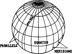
TOPIC 3 GEOGRAPHY AND PLOTTING To gain a greater knowledge of time theory and time conversion computations, we must have a complete understanding of the Earth, upon which we navigate and travel. Reference points for locating objects on the Earth have been established by general agreement among maritime nations. The North and South poles are at the ends of the axis on which the Earth rotates. Imaginary lines (an infinite number of them) running through the poles and around the Earth are called meridians. They divide the Earth into sections. The Equator is an imaginary line around the Earth that bisects every meridian and divides the Earth in half: the Northern Hemisphere and the Southern Hemisphere. Meridians and the Equator are called great circles because they each divide the world into halves. Any circle drawn around the Earth so as to divide it into equal parts is called a great circle. Measurement along a meridian is expressed in degrees, minutes, and seconds of arc. Each degree contains 60 minutes each minute, in turn, contains 60 seconds MERIDIANS For every degree around the Earth, there is a meridian. There are 360 of them 60', or 3600", apart. The starting point for numbering meridians is the one passing through the Royal Observatory at Greenwich, England.
Figure 3-1.-Meridians and parallel The Greenwich meridian is number 0. Meridians run east and west from 0 to the 180th meridian on the opposite side of the Earth. The complete circle formed by the 0 and the 180th meridians, like the Equator, divides the Earth into two exact halves: the Eastern Hemisphere and the Western Hemisphere. Every meridian runs true north and south. PARALLELS We need a second set of imaginary lines to complete our coordinate system. These lines are formed by planes that are parallel to the plane passing through the Earth at the Equator. The lines on the Earth resulting from cutting it with these parallel planes are circles called parallels. The starting point for numbering these parallels is the Equator. They are numbered from 0 to 90 north and south of the Equator. The system is shown in 1 ure -
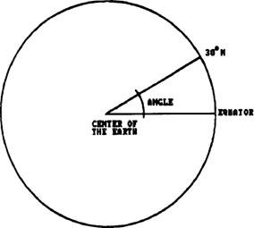
Figure 3-2.-Measuring parallels of latitude. |
|
Privacy Statement - Press Release - Copyright Information. - Contact Us - Support Integrated Publishing |