Custom Search
|
|
 
|
||
|
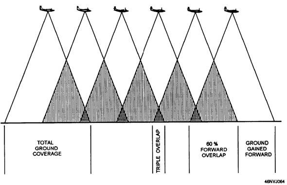
FORWARD OVERLAP To ensure complete coverage of the area, you should take each photograph in each flight line or strip so it overlaps both the preceding photograph and the following photograph. The amount of overlap on each photograph is approximately 60 percent. Creating this overlap ensures that the strip contains no blank areas (fig. 4-17). The overlap also serves another important function. In the construction of a mosaic map, only the central area of each print is used. Only the central area is used because the middle areas of all vertical photographs are the area of truest reproduction of terrain. (See fig 4-18) In figure 4-18 the aircraft is flying over a mountain while making a series of vertical photographs. For all practical purposes, when the aircraft is directly over the mountain, a perfect reproduction of the mountain is obtained. Pictures taken before and after the one directly over the mountain show the near side of the mountain clearly, but very little, if any, of the far side. This is caused by the different camera positions in respect to the subject. Scale is affected by this difference of camera positions. It is practically impossible to match the edges of prints when these distortions of the terrain are present. Therefore, the outer area (toward the edges of the print) is discarded and the inner 40 percent of each print is used. Another important reason for using only the center area of the prints is that stereoscopic measurement associated with either contour mapping or photographic interpretation requires the highest degree of accuracy. Since a 60-percent overlap is created, only 40 percent of the ground-gained forward (GGF) is usable in each negative. For example, a 5- x 5-inch negative has a usable image area of 2 inches. (5.0 x 0.40 = 2.) To find the actual amount of usable GGF in each negative, multiply the ground coverage by 0.40. For example, using the IFGA formula, you have determined that the ground coverage for each negative is 9,000 feet. The usable GGF in each negative is 3,600 feet (9,000 x 0.40 = 3,600). SIDE LAP The area that you are photographing for a mosaic map may be wide and cannot be photographed in one strip. The aircraft must fly a number of side-by-side strips to get complete coverage so none of the area is
Figure 417-Forward overlap.
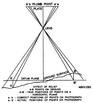
Figure A-18-Effect on scale when photographing over rough terrain. missed. Since only the central portion of each photograph is used in a mosaic map, each successive strip must overlap the preceding strip. This overlapping of strips is called SIDE LAP. Side lap for mosaic maps is usually 40 percent fig 4-19. Since each flight strip is overlapped 40 percent, only 60 percent of sideways usable area remains on each negative. To find the amount of usable ground-gained sideways, multiply the ground coverage by 0.60. For example, when the ground coverage is 9,000 feet, the usable ground-gained sideways (GGS) is 5,400 feet (9,000 x 0.60 = 5,400). The shorter dimension of the negative is always used for the GGF. This is to limit the number of flight lines to as few as possible. This helps to eliminate the
Fiunre 419.--Side lap. possible error in lining up each successive flight line. The longer dimension of the film is always used for the GGS. Figure 4-20 shows the usable portion of a 9- x 9-inch negative after the GGF and GGS have been factored in. |
 |
|
|
||