Custom Search
|
|
 
|
||
|
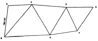
GLOBAL POSITIONING SYSTEMS Because of its superiority, the global positioning system is phasing out the use of the Doppler positioning system; however, like the Doppler system, the global positioning system is based on observations of satellites. GPS satellites are in near-circular orbits around the globe at an altitude of approximately 12,400 miles above the earth. These satellites transmit unique signals that are encoded with information that enables ground receivers to measure the travel time of the signals from satellite to receiver. That travel time is then converted to distance using the velocity of electromagnetic energy through the atmosphere. Determining point locations using GPS procedures consist essentially of measuring distances from points at unknown locations to satellites whose positions are known at the instant of observation. In concept this is identical to performing resection (chapter 9 of this TRAMAN), using distances that are measured from a point of unknown location to three or more stations whose positions are known. For a more thorough discussion of both global positioning systems and Doppler positioning systems, you can refer to commercial books, such as Elementary by Wolf and Brinker. TRIANGULATION In your previous studies you learned that a principal method of locating points in horizontal control is traversing. As you know, traversing requires that distances and angles be measured at all stations. In this chapter you will learn another method. This method triangulation requires that distances be measured only at the beginning, at specified intervals, and at the end of the survey.Both the triangulation method and the traverse method of control are based on the character of the terrain, and not on the degree of precision to be attained; that is, each system is equally precise under the conditions in which each is used. Discussion of triangulation in this chapter normally is limited to triangles having sides less than 3,000 yards in length and to triangulation nets that do not extend more than 25,000 yards. The triangulation method is used principally in situations where the chaining of distances is impossible or infeasible except with the use of electronic measuring devices. Suppose you want to locate a point, say, point C, which is offshore; and the measured baseline, AB, is located on the shore. In this situation the triangulation method is used because the chaining of distances is impossible. The chaining of long distances, especially in rough country, also is not always possible; therefore, triangulation is used to establish horizontal control in large-area surveys.In some large-area surveys conducted by triangulation, you must consider factors involving the curvature of the earth; hence, in such cases, geodetic triangulation is involved. Whether or not the curvature of the earth must be considered depends upon the area covered and the precision requirements of the survey. The error resulting in horizontal measurements when you ignore the curvature of the earth amounts to about 1 foot in 34 1/2 miles. This means that in most ordinary surveying, an area of 100 square miles may be plane-triangulated without significant error. In this discussion we are concerned with plane triangulation only. For a discussion of geodetic triangulation, you should refer to commercial publications.This section contains information on the three types of triangulation networks and the usual procedure for conducting a triangulation survey. Also covered are primary and secondary triangulation stations, types of signals used in marking triangulation stations, and checking for precision and locations of points. SUPERVISION AND TRIANGULATION SURVEYS In triangulation surveys, the duties of the EA1 are those of party chief; that is, he directs the triangulation survey. He keeps the triangulation notes and should be at the spot where any important measurement is made so that he can verify the readings personally. He is responsible for selecting triangulation stations and erecting triangulation signals and towers. He determines the degree of precision to be attained. He also performs the computations necessary to determine horizontal locations of the points in the triangulation system by bearing and distance. Triangulation is used extensively as a means of control for topographic and similar surveys. A triangulation system consists of a series of triangles. At least one side of each triangle is also aside of an adjacent triangle; two sides of a triangle may form sides of adjacent triangles. By using the triangulation method of control, you do not need to measure the length of every line. However, two lines are measured in each systemone line at the beginning and one at the closing of the triangulation system. These lines are called base lines and are used as a check against the computed lengths of the other lines in the system. The recommended length of a base line is usually one sixth to one fourth of that of the sides of the principal triangles. The transcontinental system established by the U.S. Coast and Geodetic Survey (now the National Geodetic Survey) is an example of an extensive
Figure 15-15.-Chain of single triangles. high-order triangulation network to establish control across the United States. |
 |
|
|
||