| Tweet |

Custom Search
|
|
 
|
||
|
Contour
Lines There are several ways of indicating elevation and relief on maps. The most common way is by contour lines. A CONTOUR LINE is a line representing an imaginary line on the ground along which all points are at the same elevation. Contour lines indicate a vertical distance above or below a datum plane. Starting at sea level, normally the zero contour, each contour line represents an elevation above sea level. The vertical distance between adjacent contour lines is known as the CONTOUR INTERVAL. The amount of the contour interval is given in the marginal information. On most maps, the contour lines are printed in brown. Starting at zero elevation, every fifth contour line is drawn with a heavier line. These are known as INDEX CONTOURS. Someplace along each index contour, the line is broken and its elevation is given. The contour lines falling between index contours are called INTERMEDIATE CONTOURS. They are drawn with a finer line than the index contours and, usually, do not have their elevations given. Using the contour lines on a map, you may determine the elevation of any point as follows: 1. Find the contour interval of the map from the marginal information, and note both the amount and the unit of measure. 2. Find the numbered contour line (or other given elevation) nearest the point for which the elevation is being sought. 3. Determine the direction of slope from the numbered contour line to the desired point. 4. Count the number of contour lines that must be crossed to go from the numbered line to the desired point and note the direction-up or down. The number of lines
Figure
5-6.-Estimating elevations between contour lines.
Figure
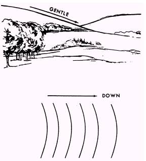
5-7.-Uniform, gentle slope. crossed multiplied by the contour interval is the distance above or below the starting value. When the desired point is on a contour line, its elevation is that of the contour. For a point between contours, most military needs are satisfied by estimating the elevation to an accuracy of one half of the contour interval. All points less than one fourth of the distance between the lines are considered to be at an elevation of one half of the contour interval above the lower line (fig. 5-6). To estimate the elevation of the top of an unmarked hill, add half of the contour interval to the elevation of the highest contour line around the hill.
Figure
5-8.-Uniform, steep slope. To estimate the elevation of the bottom of a depression, subtract half of the contour interval from the value of the lowest contour around the depression. On some maps, the index and intermediate contour lines do not show the elevation and relief in as much detail as may be needed; then SUPPLEMENTARY CONTOURS may be used. These contour lines are dashed brown lines, usually at one half of the contour interval for the map. A note in the marginal information indicates the interval used. They are used exactly like solid contour lines. On some maps, the contour lines may not meet the standards of accuracy but are sufficiently accurate in both value and interval to be shown as contours rather than as form lines. On maps of this type, the contours are considered as approximate and are shown with a dashed symbol; elevation values are given at intervals along the heavier (index contour) dashed lines. The
Figure
5-9.-Concave slope. contour note in the map margin identifies them as approximate contours. In addition to the contour lines, bench marks and spot elevations are used to indicate points of known elevation on the map. BENCH MARKS, the more accurate of the two, are symbolized by a black X, for example, XBM 124. The elevation value shown in black refers to the center of the X. SPOT ELEVATIONS, shown in brown, generally are located at road junctions, on hilltops, and other prominent landforms. The symbol ^P^P designates an accurate horizontal control point. When a bench mark and a horizontal control point are located at the same point, the symbol BM^P^P^P is used. The spacing of the contour lines indicates the nature of the slope. Contour lines evenly spaced and wide apart indicate a uniform, gentle slope (fig. 5-7). Contour lines evenly spaced and close together indicate a uniform, steep slope. The closer the contour lines are to each other, the steeper the slope (fig. 5-8). Contour lines closely spaced at the top and widely spaced at the bottom indicate a concave slope (fig. 5-9). Considering relief only, an observer at the top of a concave slope can observe the entire slope and the
Figure
5-10.-Convex slope.
Figure 5-11.-Hill. Figure
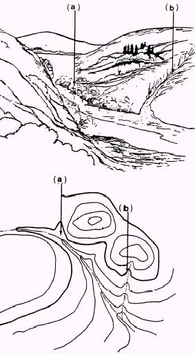
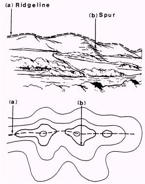
5-12.-(a) Valley; (b) Draw. terrain at the bottom. However, a unit attacking up a concave slope would have no cover or conceal-ment from observers or weapons at or near the top; also, farther up the slope, the climb would be more difficult. Contour lines widely spaced at the top and closely spaced at the bottom indicate a convex slope (fig. 5-10). An observer at the top of a convex slope would have no observation of most of the slope or of the terrain at the bottom. But a unit attacking up a concave slope would have a much greater degree of cover and concealment than on a concave slope; also, the climb farther up the slope would be easier. In order to show the relationship of land formations to each other and how they would be symbolized on a
Figure
5-13.-(a) Ridge; (b) Spur. contour map, stylized panoramic sketches of the major relief formations are drawn. Then a contour map of each sketch is developed. Each of the figures that follow shows a sketch and a map with a different relief feature and its characteristic contour pattern. 1. HILL. This is a point or small area of high ground (fig. 5-11). When you are located on a hilltop, the ground slopes down in all directions. 2. VALLEY. A valley is a course of a stream that has at least a limited extent of reasonably level ground bordered on the sides by higher ground. (See fig. 5-12, views A and B, top and bottom.) The valley generally has maneuvering room within its confines. Contours indicating a valley are U-shaped and tend to parallel a major stream before crossing it. The more gradual the fall of a stream, the farther each contour parallels it. The curve of the contour crossing always points upstream. 3. DRAW. A draw is a less developed course of a stream in which there is essentially no level ground and, therefore, little or no maneuvering room within its confines. (See fig. 5-12, views A and B, top and
Figure
5-14.-Saddle. bottom.) The ground slopes upward on each side and toward the head of the draw. Draws occur frequently along the sides of ridges at right angles to the valleys between them. Contours indicating a draw are V-shaped, with the point of the V toward the head of the draw. 4. RIDGE. Normally, a ridge is a line of high ground with minor variations along its crest. (See fig. 5-13, views A and B, top and bottom.) The ridge is not simply a line of hills; all points of the ridge crest are appreciable y higher than the ground on both sides of the ridge. 5. SPUR. A spur is a short, continuously sloping line of higher ground normally jutting out from the side of a ridge. (See fig. 5-13, views A and B, top and bottom.) A spur is often formed by two roughly parrallel streams cutting draws down the side of a ridge. 6. SADDLE. A saddle is a dip or low point along the crest of a ridge. A saddle is not necessarily the lower ground between two hilltops; it maybe simply a dip or break along an otherwise level ridge crest (fig. 5-14).
Figure
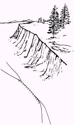
5-15.-Cliff. 7. CLIFF. A cliff is a vertical or near vertical slope (fig. 5-15). When a slope is so steep that it cannot be shown at the contour interval without the contours coming together, it is shown by a ticked "carrying" contour or contours. The ticks always point toward lower ground. 8. CUTS and FILLS. Cuts and falls are man-made features caused when the bed of a road or railroad is graded or leveled by cutting through high areas and filling in low areas along the right-of-way. (See fig. 5-16, views A and B, top and bottom.) 9. DEPRESSION. A depression is a low point or a sinkhole, surrounded on all sides by higher ground (fig. 5-17). |
 |
|
|
||