| Tweet |

Custom Search
|
|
 
|
||
|
MARKING THE LANDING ZONE Once you have established the LZ, the landing sites, and the landing points, you need to direct the helicopter to the location of the LZ. The proper marking of the LZ will aid the pilot in locating it.
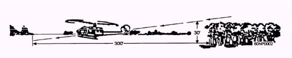
Figure 3-2.- Horizontal clearance.
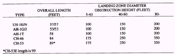
Figure 3-3.- Landing point dimensions.
Figure 3-4.- Landing zone diameter. Recommendations for marking an LZ and for guiding a helicopter to an LZ are as follows: 1. Daylight landing: The landing zone is equipped with a means of showing wind direction and velocity. This is usually accomplished by the use of smoke or by verbal radio message. Expedient methods for determining wind direction and velocity are as follows: a. Grass drop method. Extend your arm straight out and drop the grass from your hand. Point the extended arm at the dropped grass on the ground. The angle between the arm and the body divided by four is the wind velocity in knots. b. Angle of smoke method. Observe the angle at which smoke blows. The wind speed is as follows: -If smoke goes straight up, no wind. -If smoke blows at a 30-degree angle, wind is 3-5 knots. -If smoke blows at a 60-degree angle, wind is 5-7 knots. -If smoke blows along the ground, wind exceeds 8 knots. Use smoke and landing zone panels to mark a landing zone by day. Both should be the same color as the designation of the landing zone. This will aid the pilot in locating the landing zone, Mark obstacles that cannot be removed within the landing zone with single red panels staked to prevent uprooting by rotor wash. SECURITY CAUTION: If smoke is used to mark the landing zone, use only as needed and do not tell the pilot the color of smoke; ask the pilot to acknowledge the color after the smoke grenade is set off. 2. Night landing: The organization and use of an LZ at night or during periods of low visibility is more complex compared to daytime operations. Special lighting equipment or field expedients as required. a. You must indicate outlines of landing zones by low-intensity markers. b. You must show obstacles near the landing zone by low-intensity markers or voice radio instructions. Another method of guiding the aircraft to the zone is vector instructions. This is simply relaying instructions to the pilot by radio. For example, the radio operator spots the helicopter. Using a compass, the radio operator shoots an azimuth of 135 degrees from the LZ to the helicopter and quickly computes a back azimuth of 315 degrees. The radio operator then transmits the following message: "HOME WISH, THIS IS FLIGHT BEE . . . VECTOR THREE ONE FIVE TO LANDING ZONE HAWK . . . OVER." The pilot then acknowledges the message and takes up the correct heading of 315 degrees. The term vector is always used in a situation like this to prevent misunderstanding. As the helicopter approaches, minor corrections will probably be necessary. These are given as corrections to the original heading b y the following: "HOME WISH, THIS IS FLIGHT BEE. . . COME RIGHT FIVE DEGREES OF PRESENT COURSE. . . OVER." When the tactical situation does not allow the use of a compass, you can vector the helicopter to an LZ by using the clock system: "HOME WISH, THIS IS FLIGHT BEE . . . MY POSITION IS AT YOUR NINE O'CLOCK . . . OVER." The aircraft would then execute a 90-degree turn to the left.
|
||
|
||