Custom Search
|
|
 
|
||
|
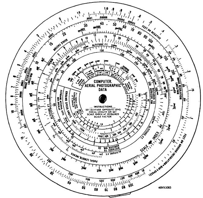
AERIAL PHOTOGRAPHIC DATA COMPUTER An aerial photographic coverage and flight planning computer, such as the Aerial Photographic Data Computer (Type BM-38A). can assist you with many of the calculations required for mission planning. The aerial photographic data computer contains scales, indices, and information pertaining to frame and panoramic camera photography as well as radar and infrared detection mapping. This computer is a useful tool in mission planning. It can provide quick responses to a number of mission requirements flg.4-16 . The aerial computer is designed primarily for large-format automated camera systems. However, it is helpful in making calculations for hand-held aerial photography when 70mm film is involved (using the Bronica ETRS or Agiflite, for example). Information that can be provided by the aerial calculator is as follows: Scale index Scale factor Focal length required Ground coverage Altitude
Figure 4-16.-Aerial photographic data computer (front). Exposure interval (in seconds) for 60-percent overlap Ground gained Ground coverage per inch of negative and exposure intervals When you intend to use the BM-38A computer, refer to the Photographic Computer Instruction Book, RC-025063, for detailed instructions. SCALE Usually, the area to be mapped is indicated on a chart and maximum boundaries are provided. The scale fraction of this chart, or its linear scale, provides important information. The amount of area to be covered can be determined from one of these scales. The scale of a map is indicated as a common fraction or as a ratio. For example, the scale may be 1/10,000 or 1:10,000 on the map. In either case, the scale is read "one to ten thousand." This scale indicates that one unit of measure on the map is equal to 10,000 of the same units on the ground. One problem in aerial mapping is locating the scale of the mosaic map. When the required scale is provided, then the altitude and focal length must be determined to get the required scale. The scale of a photographic mosaic map is calculated as follows: S = Scale of the map F = Focal length of the lens A = Altitude above the ground With F (in inches), A (in feet) must be multiplied by 12 to convert to the same unit of measurement (inches).
Example: What is the scale of a map taken from an altitude of 5,000 feet, using a 6-inch lens.
Therefore, the scale is 1/10,000. That means 1 inch on the photograph equals 10,000 inches on the ground. |
 
|
|
|
||