Custom Search
|
|
 
|
||
|
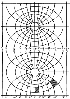
Transverse Mercator Projection On a Mercator projection the cylinder is placed tangent to the earths central parallel, the equator. On
Figure 9-12.Meridians and parallels on a Mercator projection.a transverse Mercator projection, the cylinder is ro-tated 90 degrees from this position to bring it tangent to a meridian. Figure 9-13 shows the appearance of the meridians and parallels on the transverse Mercator world projection when the cylinder is flattened out. In this case, the cylinder was placed tangent to the meridian running through 0-degrees and 180-degrees longitude.You can see that, in general, a transverse Mercator projection has less distortion than a Mercator projection does. You also can see that, unlike distortion on a Mercator projection, distortion on a transverse Mercator increases with longitude as well as with latitude away from the meridian of tangency. This is indicated by the shaded areas shown in figure 9-13. These areas are the same size on the ground. Since they lie in the same latitude, they would have the same size on a Mercator projection. On the transverse Mercator projection, however, the area in the higher longitude would be larger.The important thing to note about the transverse Mercator, however, is the fact that in any given area the distortion is about the same in all directions. It is this fact that makes the transverse Mercator the most feasible projection for use with the military grid reference system.A rhumb line is a curve on the surface of a sphere that cuts all meridians at the same angle. A mathematical navigational device, developed to plot the Mercator-projected maps, makes the rhumb line a straight line on the chart, thus preserving the same angle of bearing with respect to the intersected
Figure 9-13.Meridians and parallels on a transverse Mercator projection. meridians as does the track of a vessel under a true course. On the globe the parallels become shorter toward the poles, and their length is proportionate to the cosine of latitude. In the Mercator projection the parallels are equally long. This means that any parallel is increased by 1/cos q, or sec q, where q is the latitude in degrees. To have the same scale along the parallels as along the meridians, you must increase each degree of latitude by the secant of the latitude. In this math-ematical transformation, the tangent cylinder concept was not employed, nor is it ever employed, in the Mercator projection. A Mercator projection table is used to plot the meridional distances. For intensive study on elements of map projection, you may refer to special publications published by the U.S. Coast and Geodetic Survey that deal with this subject. |
||
|
||