Custom Search
|
|
 
|
||
|
RECOMMENDED PROCEDURES FOR
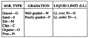
SOIL SURVEYS The following guide and step-by-step procedures will help the military engineer when conducting soil surveys:. considerations include soil types, securing of samples, density and moisture content of soil in place, drainage characteristics, and depth to groundwater and bedrock.. Published information includes geological and topographic reports with maps and agricultural soil bulletins with maps. These require careful interpretation and knowledge of local terms. Aerial photographs used to predict subsurface conditions and previous explorations for nearby construction projects are also useful.. Field information requires general observation of road cuts, stream banks, eroded slopes, earth cellars, mine shafts, and existing pits and quarries. Test holes may be made with a hand auger or a power auger, if necessary and available. Test pits are necessary where a hand auger cannot penetrate or where large samples are required.. Local inhabitants, preferably trained observers such as contractors, engineers, and quarry workers, can provide valuable information.Preparation Planning of the general layout will determine the extent of the various soil types, vertically and laterally, within the zone where earthwork may occur. Large cuts and fills are the most important areas for detailed exploration. . Airfield exploration. Place borings at high and low spots, wherever a soil change is expected and in transitions from cut to fall. There is no maximum or minimum spacing requirement between holes; however, the number of holes must be sufficient to give a complete and continuous picture of the soil layers throughout the area of interest. As a general rule, the number of exploration borings required on a flat terrain with uniform soil conditions will be less than in a terrain where the soil conditions change frequently. . Exploration borings should be conducted at the point of interest and located in a manner to get the maximum value for each boring. This may require exploration boring in the centerline as well as edges of runways or roads, but no specific pattern should be employed except as perhaps a staggered or offset pattern to permit the greatest coverage. It is accepted policy to conduct the exploration borings at the edge of existing pavements, unless these pavements have failed completely. In this case, the reason for the failure should be found. . Depth exploration. Take a cut section 4 feet below subgrade, if possible, and a fill section 4 feet below original ground level, if possible. Effort should be made to locate the groundwater table.Procedures . Log the exploration holes or pits. . Locate and number the samples. . Determine the elevation and exact location of each hole and tie into the site layout.Technical Soils Report A good program for soils testing not only requires that careful and complete tests be performed but also that the tests be completed as quickly as possible and that the data be clearly and accurately presented in a technical soils report. The organization and presentation of the soils report is highly important. The report must be well-organized and must be presented in a logical and concise format with emphasis on technical conclusions. For further discussion and a suggested outline for a soils report, you should refer to Materials Testing, NAVFAC MO-330.SOIL CLASSIFICATION The principal objective of soil classification is the prediction of engineering properties and behavior of a soil based on a few simple laboratory or field tests. The results of these tests are then used to identify the soil and put it into a group of soils that have similar engineering characteristics. Although there are several different methods of soil classification, the method adopted for use by the military is the Unified Soil Classification System (USCS).Soils seldom exist in nature separately as sand, gravel, or any other single component. Soils usually form mixtures with varying proportions of different size particles. Each component contributes to the characteristics of the mixture. The USCS is based on the textural or plasticity-compressibility characteristics that indicate how a soil will behave as a construction material.In the USCS, all soils are divided into three major divisions: (1) coarse grained, (2) fine grained, and (3) highly organic. As you know from your previous studies, coarse-grained and fine-grained soils are distinguished by the amount of material that is either retained on or that passes a No. 200 sieve. If 50 percent or more of the soil by weight is retained on a No. 200 sieve, then the soil is coarse-grained. It is fine-grained if more than 50 percent passes the No. 200 sieve. Highly organic soils can generally be identified by visual examination. The major divisions are further subdivided into soil groups. The USCS uses 15 groups and each group is distinguished by a descriptive name and letter symbol, as shown in table AV-1 of appendix V. The letter symbols are derived either from the terms descriptive of the soil fractions, the relative value of the liquid limit (high or low), or the relative gradation of the soil (well graded or poorly graded). The letters that are used in combination to form the 15 soil groups areas follows:
|
 
|
|
|
||