Custom Search
|
|
 
|
||
|
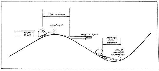
VERTICAL CURVES In addition to horizontal curves that go to the right or left, roads also have vertical curves that go up or down. Vertical curves at a crest or the top of a hill are called summit curves, or oververticals. Vertical curves at the bottom of a hill or dip are called sag curves, or underverticals.GRADES Vertical curves are used to connect stretches of road that go up or down at a constant slope. These lines of constant slope are called grade tangents (fig. 11- 13). The rate of slope is called the gradient, or simply the grade. (Do not confuse this use of the term grade with other meanings, such as the design
Figure 11-13.A vertical curve. elevation of a finished surface at a given point or the actual elevation of the existing ground at a given point.) Grades that ascend in the direction of the stationing are designated as plus; those that descend in the direction of the stationing are designated as minus. Grades are measured in terms of percent; that is, the number of feet of rise or fall in a 100-foot horizontal stretch of the road.After the location of a road has been determined and the necessary fieldwork has been obtained, the engineer designs or fixes (sets) the grades. A number of factors are considered, including the intended use and importance of the road and the existing topography. If a road is too steep, the comfort and safety of the users and fuel consumption of the vehicles will be adversely affected; therefore, the design criteria will specify maximum grades. Typical maximum grades are a 4-percent desired maximum and a 6-percent absolute maximum for a primary road. (The 6 percent means, as indicated before, a 6-foot rise for each 100 feet ahead on the road.) For a secondary road or a major street, the maximum grades might be a 5-percent desired and an 8-percent absolute maximum; and for a tertiary road or a secondary street, an 8-percent desired and a 10-percent (or perhaps a 12-percent) absolute maximum. Conditions may sometimes demand that grades or ramps, driveways, or short access streets go as high as 20 percent. The engineer must also consider minimum grades. A street with curb and gutter must have enough fall so that the storm water will drain to the inlets; 0.5 percent is a typical minimum grade for curb and gutter (that is, 1/2 foot minimum fall for each 100 feet ahead). For roads with side ditches, the desired minimum grade might be 1 percent; but since ditches may slope at a grade different from the pavement, a road may be designed with a zero-percent grade. Zero-percent grades are not unusual, particularly through plains or tidewater areas. Another factor considered in designing the finished profile of a road is the earthwork balance; that is, the grades should be set so that all the soil cut off of the hills may be economically hauled to fill in the low areas. In the design of urban streets, the best use of the building sites next to the street will generally be more important than seeking an earthwork balance.COMPUTING VERTICAL CURVES As you have learned earlier, the horizontal curves used in highway work are generally the arcs of circles. But vertical curves are usually parabolic. Thehorizontal distance from the beginning to the end of the curve; the length of the curve is NOT the distance along the parabola itself. The longer a curve is, the more gradual the transition will be from one grade to the next; the shorter the curve, the more abrupt the change. The change must be gradual enough to provide the required sight distance (fig. 11- 14). The sight distance requirement will depend on the speed for which the road is designed; whether passing or nonpassing distance is required; and other assumptions, such as ones reaction time, braking time, stopping distance, height of ones eyes, and height of objects. A typical eye level used for designs is 4.5 feet or, more recently, 3.75 feet; typical object heights are 4 inches to 1.5 feet. For a sag curve, the sight distance will usually not be significant during daylight; but the nighttime sight distance must be considered when the reach of headlights may be limited by the abruptness of the curve.ELEMENTS OF VERTICAL CURVES Figure 11-15 shows the elements of a vertical curve. The meaning of the symbols and the units of measurement usually assigned to them follow: PVC Point of vertical curvature; the place where the curve begins.PVI Point of vertical intersection; where the grade tangents intersect. PVT Point of vertical tangency; where the curve ends. POVC Point on vertical curve; applies to any point on the parabola. POVT Point on vertical tangent; applies to any point on either tangent. gI Grade of the tangent on which the PVC is located; measured in percent of slope. g2 Grade of the tangent on which the PVT is located; measured in percent of slope.
Figure 11-15.Elements of a vertical curve.
Figure 11-14.Sight distance. G The algebraic difference of the grades: G = g2 -g1,wherein plus values are assigned to uphill grades and minus values to downhill grades; examples of various algebraic differences are shown later in this section.L Length of the curve; the horizontal length measured in 100-foot stations from the PVC to the PVT. This length may be computed using the formula L = G/r, where r is the rate of change (usually given in the design criteria). When the rate of change is not given, L (in stations) can be computed as follows: for a summit curve, L = 125 x G/4; for a sag curve, L = 100 x G/4. If L does not come out to a whole number of stations using these formulas, then it is usually extended to the nearest whole number. You should note that these formulas for length are for road design only, NOT railway. l1 Horizontal length of the portion of the PVC to the PVI; measured in feet.12 Horizontal length of the portion of the curve form the PVI to the PVT; measured in feet.e Vertical (external) distance from the PVI to the curve, measured in feet. This distance is computed using the formula e = LG/8, where L is the total length in stations and G is the algebraic difference of the grades in percent.
Figure 11-16.Algebraic differences of grades. x Horizontal distance from the PVC to any POVC or POVTback of the PVI, or the distance from the PVT to any POVC or POVT ahead of the PW, measured in feet. y Vertical distance (offset) from any POVT to the corresponding POVC, measured in feet;
which is the fundamental relationship of the parabola that permits convenient calculation of the vertical offsets. The vertical curve computation takes place after the grades have been set and the curve designed. Therefore, at the beginning of the detailed computa-tions, the following are known: g1, g2, l1, l2, L, and the elevation of the PVI. The general procedure is to compute the elevations of certain POVTs and then to use the foregoing formulas to compute G, then e, and then the Ys that correspond to the selected POVTs. When the y is added or subtracted from the elevation of the POVT, the result is the elevation of the POVC. The POVC is the finished elevation on the road, which is the end result being sought. In figure 11-15, the y is subtracted from the elevation of the POVT to get the elevation of the curve; but in the case of a sag curve, the y is added to the POVT elevation to obtain the POVC elevation.The computation of G requires careful attention to the signs of g1 and g2. Vertical curves are used at changes of grade other than at the top or bottom of a hill; for example, an uphill grade that intersects an even steeper uphill grade will be eased by a vertical curve. The six possible combinations of plus and minus grades, together with sample computations of G, are shown in figure 11-16. Note that the algebraic sign for G indicates whether to add or subtract y from a POVT.The selection of the points at which to compute the y and the elevations of the POVT and POVC is generally based on the stationing. The horizontal alignment of a road is often staked out on 50-foot or 100-foot stations. Customarily, the elevations are computed at these same points so that both horizontal and vertical information for construction will be pro-vided at the same point. The PVC, PVI, and PVT are usually set at full stations or half stations. In urban work, elevations are sometimes computed and staked every 25 feet on vertical curves. The same, or even closer, intervals may be used on complex ramps and interchanges. The application of the foregoing funda-mentals will be presented in the next two sections under symmetrical and unsymmetrical curves. |
||
|
||