|
||
|
|
||
|
Page Title:
Computation of derived measurements |
||
| |||||||||||||||
|
|
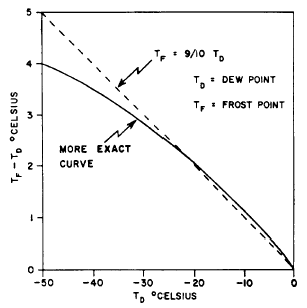
COMPUTATION OF DERIVED MEASUREMENTSNow that you understand what all those strange looking lines represent, we can use the plotted temperature, dew point, and height data to find some additional data measurements. This data normally would be calculated using complex formulas from the reported data. On the Skew T, we simply follow the correct lines to find the values. We will derive measurements for the potential temperature, frost point temperature, saturation mixing ratio, actual mixing ratio, relative humidity, wet-bulb temperature, wet-bulb potential temperature, virtual temperature, and layer thickness in this manner.Potential Temperature Potential temperature is the temperature a parcel of air can attain if it descends dry adiabatically to the 1,000-millibar level. Since the dry adiabats are labeled in degrees Celsius and coincide with the isotherms at the 1,000-millibar level, we can see that the dry adiabats actually are potential temperature lines. To find the potential temperature of a parcel of air, interpolate the value of the plotted temperature by using the dry adiabats closest to the temperature plot. You may find it easier to read the value by drawing a light pencil line parallel to the dry adiabats either upward to the top of the diagram where the values are printed or downward to the 1,000-millibar level and reading the isotherm value.Frost Point Temperature Frost point is the temperature to which air has to be cooled to reach saturation with respect to ice. The frost point is always warmer than the dew point below zero degrees Celsius. An approxima-tion of the frost point temperature may be made using the formula
While this formula does not yield an exact frost point temperature, it is quickly and easily computed. See figure 6-2-1. The frost point temperature should be computed and plotted for all levels above the point where the air temperature crosses the 0C isotherm. This is especially important when analyzing the Skew T for cloud layers. The frost point curve will fall between the temperature and the dew point curve unless the cloud is super-saturated with respect to ice. In this case, the frost point curve will cross to the right of the tem-perature curve. In clouds with temperatures above freezing, the true dew point will coincide closely with the true temperature, indicating that the air between the cloud droplets is practically saturated with respect to the water surface of the droplets. Minor discrepancies may exist when the cloud is not in a state of equilibrium (when the cloud is forming
Figure 6-2-1.-Frost point temperature comparison. or dissolving rapidly), or when precipitation is falling through the cloud with temperatures slightly different from the air temperature. These differences are small theoretically. In the sub-freezing part of the cloud, the true temperature at which condensation occurs will fall between the frost point temperature and the dew point temperature. If the cloud consists entirely of supercooled water droplets, this temperature will be the same as the dew point temperature. If the cloud is made entirely of ice crystals, the frost point will coincide with the true condensation temperature, which means that the moisture is changing directly from water vapor into ice crystals through sublimation. Below 12C, most clouds form through the sublimation of water vapor directly into ice crystals. We may state, as a general rule, that clouds below -12C are saturated with respect to ice; therefore, the moisture content should be evaluated by use of the frost point temperature. Above freezing, clouds are generally saturated with respect to water, and the dew point temperature should be used to evaluate the moisture content. Between the freezing point and 12C, clouds may be saturated with respect to water or to ice, or somewhere between the two values if a cloud is mixed ice and water. In the last case, the moisture content should be evaluated using both the dew point and frost point temperatures. Supersaturation with respect to ice, as indicated by the frost point temperature being greater than the air temperature, will indicate a mixed cloud or a supercooled water cloud. |
|
Privacy Statement - Press Release - Copyright Information. - Contact Us - Support Integrated Publishing |