|
||
|
|
||
| |||||||||||||||
|
|
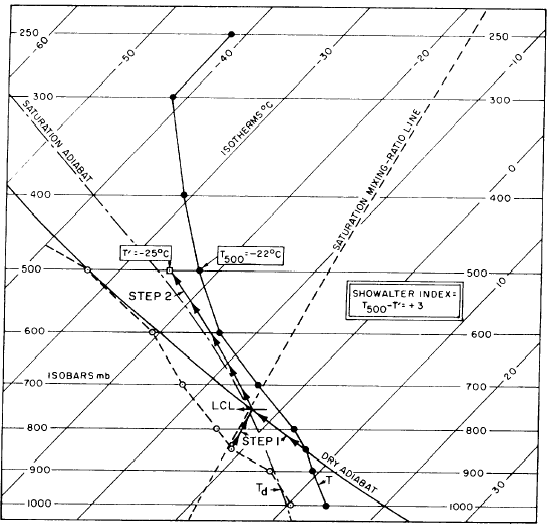
STABILITY INDICES A stability index is a computed value used to forecast the probability of convective activity. This activity may range from rain showers, through the various intensities of thunder-storms, ending up with thunderstorms producing tornadoes. Many different stability indices are currently being used as forecast aids for severe weather. We will look at the indices used most frequently that you as the analyst must be able to compute from the Skew T. These are the Showalter Stability Index, the Lifted Index, the K-Value or K Index, and the Total Totals Index.Showalter Stability Index (SSI) The Showalter Stability Index (SSI) is the stability index most used by the National Weather Service, the USAF Air Weather Service, and Navy forecasters. It indicates the general stability of an air mass and should not be used when a frontal boundary or a strong inversion is present between the 850- and 500-millibar levels. SSI is computed using the layer between 850 millibars and 500 millibars, as follows:1. Using the temperature and dew point at the 850-millibar level, determine LCL.2. From that LCL, draw a line upward parallel to the nearest saturation adiabat until it intersects the 500-millibar level. Read the temperature (T') at this point.3. Subtract T' from the actual 500-millibar temperature T500 This value, including the algebraic sign, is the SSI value. See figure 6-2-14.The probability of convective activity based m the SSI is as follows:
Figure 6-2-14.-Example of the Showalter Stability Index computation. Lifted Index Lifted Index (LI) is a modification of the Showalter Stability Index that is applicable for both air mass and frontal convective weather. The Lifted Index and the K-value (which we discuss in the following section) are routinely computed by the National Weather Service computers for all NWS U.S. Upper Reporting Stations and plotted on a chart for broadcast twice daily with the analysis package. The Lifted Index is computed from a Skew T as follows: 1. Determine the mean mixing ratio in the lowest 3,000 feet of your sounding by the equal area method. 2. Draw the expected maximum temperature adiabat: a. If the 850-millibar level is > 3,000 feet from the surface: (1) if there are thick clouds on the current sounding, extend a saturation adiabat through the 850-millibar temperature so that it intersects your mean mixing ratio line; or (2) if clouds are not expected to develop until afternoon, extend a dry adiabat through the 850-millibar temperature until it intersects the mean mixing ratio line. b. If the 850-millibar level is within 3,000 feet of the surface, use the 3 ,000-foot temperature instead of the 850-millibar temperature to construct a dry or saturation adiabat. 3. The intersection of the mean mixing ratio and the adiabat is the Lifted Index LCL. Extend a saturation adiabat upwards from this LCL to the 500-millibar level. This 500-millibar tempera-ture is assumed to be the updraft temperature within a convective cloud, should one develop. Subtract this temperature from your actual 500-millibar temperature to obtain the LI value. An example is shown in figure 6-2-15. The value of LI is approximately the same as that of SSI. |
|
Privacy Statement - Press Release - Copyright Information. - Contact Us - Support Integrated Publishing |