|
||
|
|
||
|
Page Title:
Air density and the water vapor |
||
| |||||||||||||||
|
|
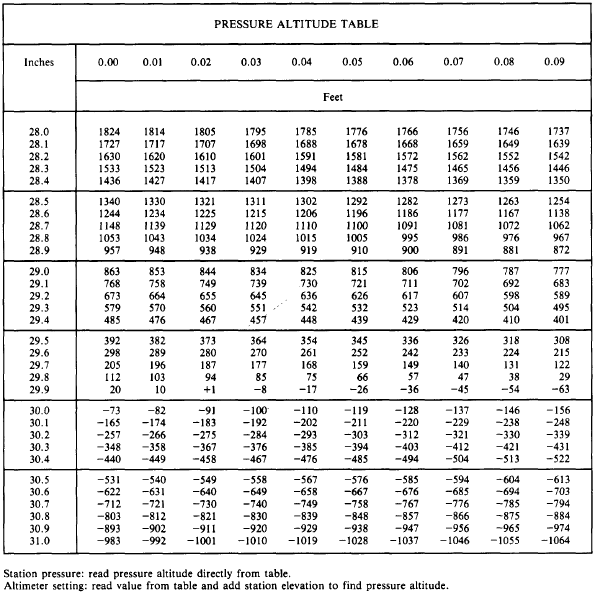
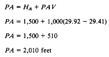
AIR DENSITY AND WATER VAPOR Air density and the water vapor content of the air have an important effect upon engine performance and the takeoff characteristics of air-craft. In this section, we will discuss some of the effects these two factors have upon engine takeoff, and the methods for computing these elements from a meteorological standpoint. The four most common elements an Aerographers Mate is asked to furnish information on are pressure altitude, density altitude, vapor pressure, and specific humidity. All of these may be determined using a Density Altitude Computer. Pressure altitude and density altitude are given in feet; vapor pressure, commonly in inches and tenths of an inch of mercury; and specific humidity, in grams per gram or in pounds per pound.Air Density The density of the atmosphere is a factor in many important problems in meteorology, as well as in the related sciences and engineering. The performance of an aircraft or missile depends on the density of the air in which it is flying. Pilots know that it is more difficult to take off from a high-altitude airport than from a low-altitude air-port and that it is more difficult to take off on a hot afternoon than on a cool morning. Since both temperature and pressure decrease with altitude, it might appear that the density of the atmosphere would remain constant with increased altitude. This is not true, for pressure drops more rapidly with increased altitude than does temperature. Since standard pressures and temperatures have been associated with each altitude, the density the air would have at those standard temperatures and pressures must be considered standard. Thus, there is associated with each altitude a particular atmospheric density. A density altitude of 15,000 feet is the altitude at which the density is the same as that considered standard for 15,000 feet. Remember, however, that density altitude is not necessarily true altitude. For example, on a day when the atmospheric pressure is higher than standard and the temperature is lower than standard, the density that is standard at 10,000 feet might occur at 12,000 feet. In that case, at an actual altitude of 12,000 feet, we would have air that has the same density as standard air at 10,000 feet.PRESSURE ALTITUDE. Pressure altitude is defined as the altitude of a given atmospheric pressure in the standard atmosphere. The pressure altitude of a given pressure is, therefore, usually a fictitious altitude, since it is equal to true altitude only rarely, when atmospheric conditions between sea level and the altimeter in the aircraft correspond to those of the standard atmosphere. Aircraft altimeters are constructed for the pressure-height relationship that exists in the standard atmosphere. Therefore, when the altimeter is set to standard mean sea level pressure (29.92 inches of mercury), it indicates pressure setting of 29.92 inches.COMPUTATIONS FOR PRESSURE ALTI-TUDE. The quickest method for approximating the pressure altitude is by using the Pressure Reduction Computer (CP-402/UM). Detailed instructions are listed on the computer. For your own station, you simply dial in the current station pressure and read the pressure altitude on the scale. The solution is more complex when converting forecast altimeter settings to pressure altitude, but the pressure reduction computer may still be used. On occasion, you may find yourself in a situation where this device is not available. Two alternate methods follow that will enable you to calculate approximations of the pressure altitude. Pressure altitude varies directly with the change in pressure multiplied by a complex variable. The variable amount takes into account temperature and station elevation. Both methods simplify the equation but still give fairly close pressure altitude approximations.The first method uses a set of precalculated pressure altitudes based on pressure differences from standard pressure. These are listed in table 6-1-5.Using the table, you may find the pressure altitude value corresponding to your current or forecast altimeter setting or the current or forecast altimeter setting for any other station. This value must be added to your station elevation or the other stations elevation to find the pressure altitude. For example, if your altimeter setting is 29.41 inches and your station elevation is 1,500 feet, you would enter the left side of the table with "29.4" and find the intersection of the column under "0.01" to find 476 feet. Add 476 feet to your station elevation, 1,500 feet, to find the pressure altitude of 1,976 feet.You may also use the table to find pressure altitude using station pressure. Station elevation should NOT be added to the value when using station pressure.The second method is useful when you do not have ready access to even the table. To calculate pressure altitude, use the formula Table 6-1-5.-Pressure Altitude Values
For example, using the formula for the same case we just calculated with the table, we find the following:
By comparison, you can see that this value is 34 feet higher than we found by using the table, but it is a close enough approximation when nothing else is available, and it may be done quickly in your head. With the pressure reduction computer, the same case yields a pressure altitude of 1,979 feet. Pilots of aircraft, especially rotary wing air-craft, frequently ask for maximum pressure other stations forecast to determine if the forecast QNH will be valid during the time the aircraft will be in the vicinity. Many rotary wing aircraft have a table in their aircraft technical data which is entered using maximum pressure altitude and maximum tem-perature to find the maximum permissible load that can be carried. Maximum pressure altitude may be used by the pilot in lieu of density altitude. |
|
Privacy Statement - Press Release - Copyright Information. - Contact Us - Support Integrated Publishing |