|
||
|
|
||
| |||||||||||||||
|
|
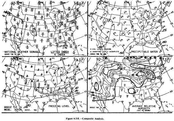
Composite Chart The composite chart is a computer-plotted, hand-analyzed four-panel chart consisting of a Lifted Index/K Index analysis, table water analysis, freezing level analysis, and average surface-to-500-millibar relative humidity analysis. These panels are shown in figure 4-3-8.
LIFTED INDEX/K INDEX PANEL. Values for both the Lifted Index (layer method) and the K Index are plotted for every reporting upper air station in the continental United States, southern Canada, and northern Mexico. The Lifted Index is plotted over the station circle and the K Index below the circle. An analysis of the Lifted Index is represented by solid lines separating the stable areas, marked with an S, from the unstable areas, marked with a U. An M is plotted for both missing data and data that cannot be computed because the station is on a high mountain. Additional information on the Lifted Index and the K Index is presented in Unit 6, Lesson 2. This information is used to forecast convective weather.PRECIPITABLE WATER. The amount of precipitable water in a column of air for each reporting station is plotted in inches. Solid lines are drawn for each half inch of water; dashed lines, for every quarter inch if necessary. Station circles are darkened for all areas exceeding 1 inch of precipitable water. This information is used as a base value in forecasting rainfall and snowfall amounts.FREEZING LEVEL. The heights of up to three freezing levels are plotted, in hundreds of feet, for each reporting station. Solid lines labeled in hundreds of feet represent the isoheight of the lowest freezing level above ground level (AGL) in intervals of 4,000 feet, while a dashed line labeled 32F represents the surface freezing isotherm. Stations with the surface temperature below freezing will show "BF" as the lowest freezing level. The heights, the number of freezing levels, and location of warm layers overlapping freezing layers are all important information in analyzing and forecasting icing conditions and precipitation type.AVERAGE RELATIVE HUMIDITY. Plotted values are the calculated average-relative-humidity percentages from the surface to 500 millibars. Thin solid lines are drawn for percent-ages from 60% to 80% and labeled, while thick solid lines are drawn for 50% and 90% humidity. Lines of equal humidity are called isohumes. The surface-to-500-millibar humidity is an important factor in convective weather and severe-weather forecasting. It is also used as a general guideline in estimating cloud coverage.12-Hour Upper-Wind Chart The eight-panel, 12-hour upper-wind chart, shown in figure 4-3-9, is transmitted twice daily after it has been calculated by the 7-layer Primitive Equation model. Twelve-hour wind forecasts and temperature forecasts are provided for 6, 9, 12, 18, 24, 30, 34, and 39 thousand feet above mean sea level (MSL). Wind direction and speed are indicated using a standard wind barb, with the tens value of the wind direction entered as a single digit near the wind feathers. The temperatures are indicated by two digits representing the tempera-ture in degrees Celsius above the station location. This same data is also sent out in bulletin format, known by the MANOP as FD (for forecast upper-level winds) bulletins. Both the chart and the bulletins are frequently used at our aviation weather offices to obtain flight level winds for flights within the continental United States. |
|
Privacy Statement - Press Release - Copyright Information. - Contact Us - Support Integrated Publishing |