|
||
|
|
||
| |||||||||||||||
|
|
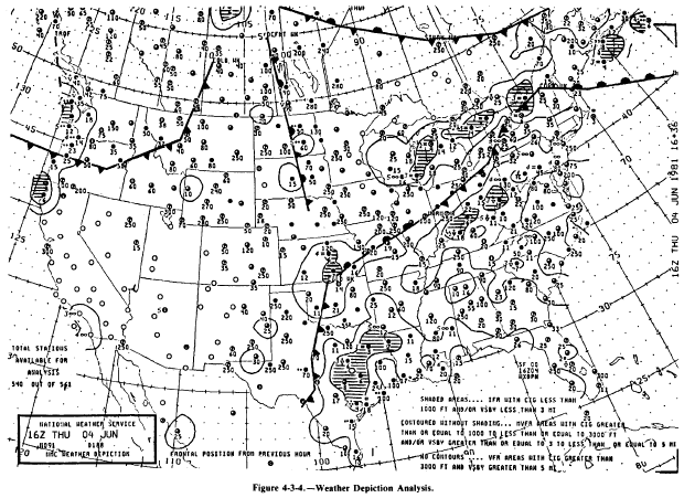
Weather Depiction Analysis The weather depiction analysis is a computer-plotted, computer-analyzed summary of aviation terminal conditions and is produced eight times a dayevery 3 hours starting at 0100Z. It is designed to be primarily a briefing tool to alert aviation interests to the location of critical and near-critical operational minimums for the United States and surrounding land areas. Figure 4-3-4 shows a typical example of this chart. The following information is depicted on each chart:Instrument Flight Rules (IFR) condition areas are enclosed by solid lines and are shaded. These are areas with ceilings below 1,000 feet and/or visibility below 3 statute miles. Marginal Visual Flight Rules (MVFR) condition areas are surrounded by a solid line but are not shaded. These are areas where the ceilings are between 1,000 and 3,000 feet and/or the visibility is between 3 and 5 statute miles inclusive. Table 4-3-1.-Frontal Type, Intensity, and Character Codes
Figure 4-3-3.-NMC weather analysis symbols. Visual Flight Rules (VFR) condition areas prevail in all other areas not surrounded by solid lines. These are areas where the ceilings are greater than 3,000 feet and the visibility is greater than 5 statute miles. Surface frontal positions from the previous hour are drawn using the standard NMC depictions. Plotted data for each terminal includes (1) significant weather symbols; (2) visibil-ity, in statute miles; (3) total sky cover, in tenths; and (4) ceiling height. All ceiling heights of the lowest layer with 5/10 or greater coverage are plotted. When total sky cover is less than 5/10, the height of the lowest scattered layer is plotted. Visibilities over 6 statute miles are not plotted. Date and time of the analysis are found in the identification block in the lower left corner of each chart.
|
|
Privacy Statement - Press Release - Copyright Information. - Contact Us - Support Integrated Publishing |