|
||
|
|
||
|
Page Title:
Numerical prediction models used by NWS |
||
| |||||||||||||||
|
|
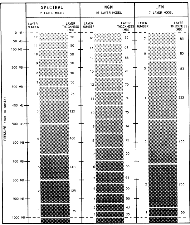
NUMERICAL PREDICTION MODELS USED BY NWSNWS currently uses several different numerical prediction models for different applica-tions. We will not go into any great detail at this level, but in AG1&C you will learn the strengths and weaknesses of each model. Limited Fine Mesh Model II The Limited Fine Mesh Model II (LFMII) is still used for many 48-hour forecasts. (These are called short-range forecasts. ) Basically, it forecasts seven layers of the atmosphere: a planetary-boundary layer 50 millibars (about 1,500 feet) above the surface; three evenly spaced layers in the troposphere, including a layer at the tropopause level; and three evenly spaced layers in the stratosphere, with the top layer at 50-millibars. See figure 4-3-1 for a diagram of the layer structure of the LFMII model. Forecasts at each layer are done on a grid with grid points about 116 kilometers apart at 45 latitude. Nested Grid Model Since late 1985 the Nested Grid Model (NGM) has also been run for the North American continent in addition to the LFM. The NGM is part of the NWS Regional Area Forecast System (RAFS) plan to improve the accuracy of numerical forecasts for the United States. It uses 16 layers in its calculations (more than twice as many as the LFM) and a series of 3 nested grids. The model makes calculations for the entire Northern Hemisphere on its coarsest (most widely spaced grid points) grid, grid A. Grid B is a finer, polar-stereographic grid; it generally covers North America, much of the Pacific, some of the Atlantic, and the polar region. Grid C is the smallest and finest-mesh grid; it covers the eastern Pacific and North America. The resolution of grid C is 84 kilometers at 45, much finer than the LFMII. The larger-amplitude atmospheric waves are calculated on the course grid, A. When these features enter the area covered by the finer grids, information is exchanged and calculations proceed on all three grids, with constant error checking. The boundary layer is only 35 millibars above the surface, or about 986 feet AGL. Figure 4-3-1 shows the vertical structure of the NGM, with the thickness, in millibars, of each of the layers. We expect that by the end of 1990, the NGM output will entirely replace the use of the LFMII output for regional forecast products in the United States. Spectral Model Since 1980, NMCs Spectral model has run as the primary operational hemispheric and global prediction model. The model routinely uses 12 layers of the atmosphere (see figure 4-3-1) and, as of 1983, calculates out to 60 hours. Resolution is somewhat finer in the lower atmospheric levels than in the stratosphere, and the overall resolution of the model is slightly finer than that of the original LFM model. Instead of performing calculations in the horizontal in a grid, like the LFM, this model calculates "modes" of the atmosphere, which can be related to calculating the wave progression and amplitude changes of the waves in the atmosphere. Some parameters,
Figure 4-3-1.-Numerical prediction model layer structure comparison. such as moisture, are calculated on an LFM-like grid. As of 1983, the Spectral model was only able to use 30 modes or waves in its calculations. In comparison, the LFM provides finer resolution. The Spectral model would require 40 to 45 modes to equal the LFMII model. Three-Layer Global Model To provide rapid computer calculations of the atmosphere for long-range forecasts, NWS uses the NMC 3-Layer Global model. This model performs calculations on three layers, from the surface to 150 millibars, and carries calculations routinely out to 11 days. The model output is primarily used for the 6- to 10-day forecasts. Although some accuracy is lost by performing calculations on fewer levels, this model is used because it requires much less computer process-ing time than the more complicated models with many layers. Barotropic Mesh Model Another forecast model is the Barotropic It is used for rapid but fairly accu-rate calculations of certain situations out to 252 hours (10 1/2 days). This model assumes that the atmosphere is barotropic; that is, both pressure patterns and thermal patterns are in-phase (isoheights and isotherms are parallel), no thermal advection occurs, and there is no slope to pressure systems in the vertical. While this concept is invalid for most pressure systems, the model does handle certain systems better than the other models, which allow temperature changes due to advection. The Barotropic model output should always be used in conjunction with other model outputs to serve as a comparison and guidance for only the barotropic-like systems. It is good guidance for forecasting jet-stream movement. |
|
Privacy Statement - Press Release - Copyright Information. - Contact Us - Support Integrated Publishing |