|
||
|
|
||
| |||||||||||||||
|
|
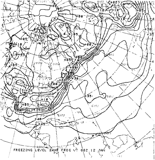
FREEZING-LEVEL CHARTS The FNOC computers calculate the freezing level during the analysis and during the fore-to cast model runs. Freezing-level analyses and prognostic data fields are produced routinely twice a day out to 72 hours. Figure 4-2-7 shows a typical freezing-level prognostic chart. Solid lines depict only the lowest freezing level. The contour labeled 00 indicates the freezing level at the surface. Additional contours are depicted every 500 meters, and labeled in hundreds of meters. Since flight weather briefs require freezing levels in feet, the user must convert the heights in meters to feet. Always be alert for signs of multiple freezing levels. The most dangerous aircraft icing, severe clear ice, can occur when liquid precipitation falls into a layer of freezing air. Precipitation in areas with multiple freezing levels may indicate severe clear icing. This chart will not indicate those situations properly.Besides producing meteorological analyses and forecast charts, FNOC also produces many oceanographic charts. Several of these oceano-graphic charts are discussed in the next section.Learning Objective: Interpret various oceanographic charts produced by FNOC. OCEANOGRAPHIC CHARTS The oceanographic charts produced by the computers at FNOC provide analyses and fore-casts of conditions that directly effect daily opera-tions in the Navys antisubmarine warfare effort, as well as routine ship operations. Computer interface with the climatological data base and with data files of current and near-current oceano-graphic observations allows development of a
Figure 4-2-7.-Freezing-level prognosis. much more accurate depiction of oceano-graphic features than is possible by a single oceanographic analyst/forecaster. However, over-smoothing of the data fields on the large-scale charts routinely transmitted via facsimile may mask significant details necessary for certain applications. Products transmitted over the unencrypted facsimile broadcast may be inten-tionally over-smoothed so as not to yield details of significant oceanographic features to non-NATO naval forces who routinely intercept and use the data from the broadcast. For applications requiring greater accuracy and detail, the Automated Product Request (APR) system should be used to receive oceanographic products via encrypted channels. In this section we will discuss the Sea Surface Temperature analysis, the Sea Surface Tempera-ture Anomaly analysis, the Significant Wave Height analysis and prognosis, the Mixed Layer Depth analysis and prognosis, and the Sonic Layer Depth analysis charts. All of these products are routinely available on Mercator projections or as polar stereographic-map projections in a wide range of map scales. The examples provided in the text are generally the larger scale map projections. |
|
Privacy Statement - Press Release - Copyright Information. - Contact Us - Support Integrated Publishing |