|
||
|
|
||
| |||||||||||||||
|
|
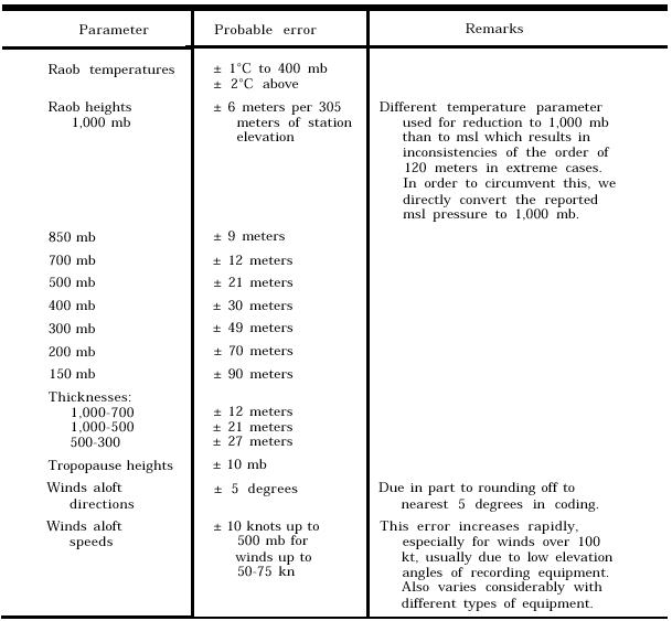
Click here to Order your Radar Equipment Online EVALUATION OF DATA Todays upper-air equipment is far better than that used only a few years ago, and it permits far more accurate readings of pressure, temperature, humidity, and wind. You must be aware, however, that the same type of errors and unrepresentative data that exists in surface reports also exists in upper-air reports. To a large extent these errors are attributable to the method used in determining the data. In many cases erroneous reports can be resolved into useable data. Common errors that sometimes can be cor-rected are communications and plotting errors, computation errors, and in the case of aircraft reports, erroneous position reports. You must exercise discretion in correcting such errors; however, do not throw away or disregard data unless you are absolutely sure it is in error and uncorrectable.Data Priority Observed data should be plotted according to the following priority:1. Radiosonde and rawinsonde observations 2. Winds aloft observations by pilot balloons (pibals)3. Weather reconnaissance aircraft observa-tions (reccos) 4. Other aircraft observations (pireps) 5. Satellite-derived information RADIOSONDES AND RAWINSONDES. These are the most all-encompassing methods of gathering upper-air information and also the most accurate. Probable errors associated with sondes are listed in table 8-1-1. WINDS ALOFT OBSERVATIONS (PI-BALS). The two biggest contributors to this datas being questionable are (1) the assumed-constant ascension rate of the balloon and (2) the timelag in the observers reading of elevation and azimuth angles. These errors become magnified in areas of high winds or large vertical wind shears. RECCOS AND PIREPS. Flight altitude data is reasonably accurate and useful. Dropsonde data is considered somewhat less accurate than data gathered by balloon-borne sondes. Position errors make these observations stand out in analysis, because they fail to fit into the height pattern.Table 8-1-1.Probable Errors in Upper Air Data
SATELLITES. Satellite pictures of Earth allow us to verify the existence, intensity, and position of weather systems. In sparse-data areas, they are our primary means of completing an analysis. |
|
Privacy Statement - Press Release - Copyright Information. - Contact Us - Support Integrated Publishing |