|
||
|
|
||
| |||||||||||||||
|
|
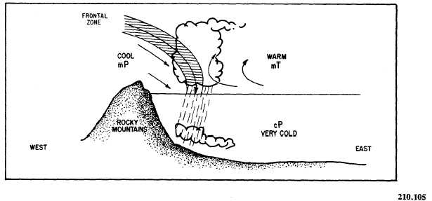
Click here to Order your Radar Equipment Online INSTABILITY AND SQUALL LINES The terms instability line and squall line are synonymous with violent winds, heavy rain, lightning, thunder, hail, and tornadoes. The terms are often used interchangeably and are incorrectly applied to any severe weather phenomena that moves through a region. However, there is a dif-ference between an instability line and a squall line.Instability Line An instability line is any nonfrontal line or band of convective activity. This is a general term and includes the developing, mature, and dissipating stages of the line of convective activity. However, when the mature stage consists of a line of active thunderstorms, it is properly termed a squall line. Therefore, in practice, the instability line often refers only to the less active phases.Squall Line A squall line is a nonfrontal line or band of active thunderstorms (with or without squalls). It is the mature, active stage of the instability line. From these definitions, instability and squall lines are air mass phenomenon because they are both nonfrontal occurrences. However, they are frequently associated with the fast-moving cold front.NOTE: The term instability line is the more general term and includes the squall line as a special case.Prefrontal Squall Lines A prefrontal squall line is a squall line located in the warm sector of a wave cyclone. They form about 50 to 300 miles in advance of fast-moving cold fronts and are usually oriented roughly parallel to the cold front. They move in about the same direction as the cold front; however, their speed is, at times, faster than the cold front. You can roughly compute the direction and speed by using the winds at the 500-mb level. Squall lines generally move in the direction of the 500-mb wind flow and at approximately 40% of the wind speed.
WEATHER.
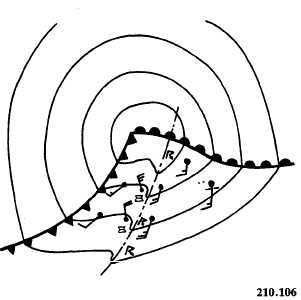
Figure 4-3-5.Typical isobaric pattern associated with a trailing cold front. Showers and thunderstorms (sometimes tornadoes) occur along the squall line, and the wind shifts cyclonically with their passage (fig. 4-3-5). However, if the zone is narrow, the wind shift may not be noticeable on surface charts. There is generally a large drop in temperature because of the cooling of the air by precipitation. Pressure rises after the passage of the squall line, and, at times, a micro-high (small high) may form behind it. After passage of the squall line, the wind backs to southerly before the cold frontal passage. When the squall line dissipates, severe weather may develop along the fast-moving cold front. Turbulence is severe in the squall-line thunderstorms because of violent updrafts and downdrafts. Above the freezing level, icing may occur. Hail is another possibility in the squall-line thunderstorm and can do extensive structural damage to an aircraft. Under the squall line, ceil-ing and visibility may be reduced because of heavy rain showers. Fog is a rare occurrence because of the strong wind and gusts, but it may be found in isolated cases. Tornadoes frequently occur with squall lines when the warm air mass is extremely unstable. |
|
Privacy Statement - Press Release - Copyright Information. - Contact Us - Support Integrated Publishing |