|
||
|
|
||
|
Page Title:
Maritime Tropical (mT) Air Pacific in Summer |
||
| |||||||||||||||
|
|
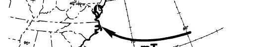
Click here to Order your Radar Equipment Online Maritime Tropical (mT) Air Pacific in Summer Maritime tropical (mT) Pacific air has no direct influence on the weather over the Pacific coast. During the summer season, the Pacific anticyclone moves northward and dominates the Pacific Coast weather with mP air. Occasionally mT air reaches the West Coast; for example, tropical storms or typhoons sometimes move northerly along the Baja Coast. This synoptic condition produces a great amount of cloudiness and precipitation.Maritime Tropical (mT) Air Atlantic in SummerThe weather in the eastern half of the United States is dominated by mT air in summer (fig. 4-1-17). As in winter, warmth and high moisture content characterize this air. In summer, convec-tive instability extends to higher levels; there is also a tendency toward increasing instability when
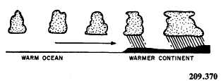
the air moves over a warmer land mass. (See fig. When mT air moves slowly northward over the continent, ground fogs frequently form at night. Sea fogs develop whenever this air flows over a relatively cold current such as that occur-ring off the east coast. The notorious fogs over the Grand Banks of Newfoundland are usually formed by this process. In late summer, the Bermuda high intensifies at times and seems to retrograde westward. This results in a general flow of mT air over Texas, New Mexico, Arizona, Utah, Colorado, and even southern California. The mT air reaching these areas is very unstable because of the intense sur-face heating and orographic lifting it undergoes after leaving the source region in the Caribbean and Gulf of Mexico. Shower and thunderstorm conditions, frequently of cloudburst intensity, then prevail over the southwestern states. Locally this condition is termed sonora weather. |
|
Privacy Statement - Press Release - Copyright Information. - Contact Us - Support Integrated Publishing |