|
||
|
|
||
| |||||||||||||||
|
|
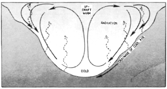
Click here to Order your Radar Equipment Online DRAINAGE WINDS. Drainage winds (also called mountain or gravity winds) are caused by the cooling air along the slopes of a mountain. Consequently, the air becomes heavy and flows downhill, producing the MOUNTAIN BREEZE. Drainage winds are katabatic winds and like glacier winds, a weak or nonexistent pressure gradient is required to start the downward flow. As the air near the top of a mountain cools through radiation or contact with colder surfaces, it becomes heavier than the surrounding air and gradually flows downward (fig. 3-3-5). Initially this flow is light (2 to 4 knots) and only a few feet thick. As cooling continues, the flow increases achieving speeds up to 15 knots at the base of the mountain and a depth of 200 feet or more. Winds in excess of 15 knots are rare and only occur when the mountain breeze is severely funneled.Drainage winds are cold and dry. Adiabatic heating does not sufficiently heat the descending air because of the relative coldness of the initial air and because the distance traveled by the air is normally short. Drainage winds have a very localized circulation.As the cold air enters the valley below, it displaces the warm air. Temperatures continue to fall. If the flow achieves speeds of 8 knots or more, mixing results between the warm valley air and the cold descending air that results in a slight temperature increase. Campers often prefer to make summer camps at the base of mountains to take advantage of the cooling effect of the mountain breeze.Winds Due To Local Heating There are two types of tertiary circulation caused by local heatingvalley breezes and thermals. VALLEY BREEZES. The valley breeze is the anabatic (uphill) counterpart of the mountain breeze. When the valley walls and mountain slopes are heated by the sun during the morning hours, the air next to the ground is heated until it rises along the slopes. Rocky or sandy slopes devoid of vegetation are the most effective heating surfaces. If the slopes are steep, the ascending
Figure 3-3-5.Mountain breeze or katabatic wind. During the night outgoing radiation cools air along hillsides below free air temperature. The cooled air drains to lowest point of the terrain. breeze tends to move up the valley walls. The expansion of the heated air next to the surface produces a slight local pressure gradient against the ground surface. As the heating becomes stronger, convective currents begin to rise vertically from the valleys (fig. 3-3-6). The updrafts along the valley walls continue to be active, particularly at the head of the valley. The valley breeze usually reaches its maximum strength in the early after-noon. It is a stronger and deeper wind than the mountain breeze. It is difficult to isolate the valley breeze effect because of the prevailing gradient winds. Consequently, the valley breeze is much more likely to be superposed as a prevailing wind than is the mountain breeze, which by its very nature can develop only in the absence of any appreciable gradient wind. The valley breezes are generally restricted to slopes facing south or the more direct rays of the sun, and they are more pronounced in southern latitudes. They are diurnally strongest in the late afternoon and are seasonally strongest in summer. THERMALS. Thermals are vertical convective currents that result from local heating. They stop short of the condensation level. Thermal convection is the usual result of strong heating of the lower atmosphere by the ground surface. A superadiabatic lapse rate immediately above the ground is necessary to the development of strong thermals. They form most readily over areas of bare rock or sand, and in particular over sand dunes or bare rocky hills. In the presence of a moderate or fresh breeze, especially in a hilly terrain, it is impossible to distinguish between turbulent and thermal convection currents. Pure thermal convection normally occurs on clear summer days with very light prevailing wind. In the eastern United States, dry thermals are usually of only moderate intensity, seldom reaching an elevation in excess of 5,000 feet above the sur-face. The high moisture content of the air masses in this section in summer reduces the intensity of the insolational heating to some extent. This moisture content usually keeps the condensation level of the surface air near or even below a height of 5,000 feet above the ground. In the dry southwestern part of the country, where ground heating during clear summer days is extreme, dry thermal convection may extend to a height of 10,000 feet or more. Under these conditions, ex-tremely turbulent air conditions can occur locally up to whatever heights the thermals extend, frequently without a cloud in the sky. One variation of the dry thermal is seen in the dust or sand whirls, sometimes called dust devils.
Figure 3-3-6.Valley breeze or anabatic wind. During the daytime hillsides heat quickly. This heating effect causes updrafts along upslopesdowndrafts in the center. They are formed over heated surfaces when the winds are very light. Dust whirls are seldom more than two or three hundred feet high, and they last only a few minutes at most. Over the desert on clear hot days as many as a dozen columns of whirling sand may be visible at once. The large desert sand whirls can become several hundred feet in diameter, extend to heights of 4,000 feet or higher, and in some cases last for an hour or more. They have been observed to rotate both anticyclonically and cyclonically, the same as tornadoes. An almost identical phenomenon is observed over water in the form of the waterspout. Waterspouts occur frequently in groups and form in relatively cool humid air over a warm water surface when the wind is light. The waterspout is visible due to the condensed water vapor, or cloud formation, within the vortex. The condensa-tion is the result of dynamic cooling by expan-sion within the vortex. In this respect it differs from the sand whirl, which is always dry. Both the sand whirl and the waterspout represent simple thermal convection of an extreme type. They are not to be confused with the more violent tornado. When dry thermal convection extends to an elevation where the dry thermals reach the con-densation level, then cumulus convection takes the place of the dry convection. Each individual ther-mal current is topped by a cumulus cloud, whose base is at the condensation level of the rising air. Beneath every building cumulus cloud a vigorous rising current or updraft is observed. Thus the local thermal convection pattern becomes visible in the cumulus cloud pattern. The cumulus clouds form first over the hills where the strongest thermals develop. Under stable atmospheric conditions, little convective cloud development occurs. However, under unstable conditions these thermals may develop cumulonimbus clouds. |
|
Privacy Statement - Press Release - Copyright Information. - Contact Us - Support Integrated Publishing |