|
||
|
|
||
|
Page Title:
Lightning detection and tracking system (LDATS) |
||
| |||||||||||||||
|
|
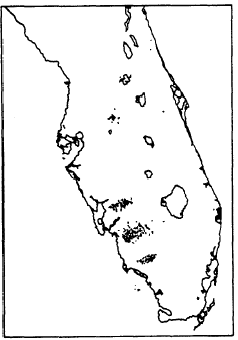
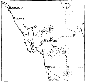
Click here to Order your Radar Equipment Online LIGHTNING DETECTION AND TRACKING SYSTEM (LDATS)The LDATS is a microprocessor-based system that displays the location of real-time or time-delayed lightning occurrences. Presentations are by way of a high-resolution color monitor (television) and/or an X, Y, or color dot matrix printer. The theory and operation of LDATS will be discussed in more detail in volume 2 of this rate training manual.The area covered by this system is displayed in map form on the color monitor or printer. The scale can be adjusted up or down by the use of a variable zoom feature. Figure 10-4-5 illustrates a typical base viewing area, while figure 10-4-6
Figure 10-4-5.Typical LDATS base viewing area.
Figure 10-4-6.-Florida west coast LDATS zoom display. shows a scaled-up map. Lightning strikes are displayed/plotted within a fraction of a second of their occurrence. Each stroke appears as a dot on the monitor and/or printer. A color-coding feature of the system changes the color of displayed strokes at 10-minute intervals. This per-mits the monitoring and tracking of the light-nings associated thunderstorm. It also allows you to gauge a thunderstorms intensity level. An in-crease in the number of electrical discharges displayed signifies an increase in intensity, while a decrease in the number of strokes displayed over a period of time indicates a lessening of storm strength.UNIT 10References A Digest of the Interpretation of Meteorological Satellite Data, Norfolk, Va., 1968.Atlantic Scientific Corporation, Operators Manual, LPATS Video Information System, 1985.Guide to Observing the Environment With Satellite Infrared Imagery, Suitland, Md., 1970. Johnson, Parmenter, and Anderson, Environ-mental Satellites; Systems, Data Inter-pretation, and Applications, Washington D.C., 1976. National Weather Service Headquarters, Office of Meteorology, for Forecasters, Handbook No. 6, 1986. Navy Tactical Applications Guide, Vol. 1, Defense Meteorological Satellite Program (DMSP), EPRF Technical Report 5-74 (WAB), Satellite Department, Environmental Prediction Research Facility, Naval Post Graduate School, Monterey, Calif., 1974.Navy Tactical Applications Guide, Vol. 2, Environmental Phenomena and Effects, EPRF Technical Report 77-04, Tactical Applications Department, Naval Envi-ronmental Prediction Research Facility, Monterey, Calif., 1979.Smith, Bishop, Dvorak, Hayden, McElroy, Mosher, Oliver, Purdom, and Wark, The Meteorological Satellite: Overview of 25 Years of Operation, for the Advancement of Science, 1986.U.S. Air Force, Application of Meteorological Satellite Data in Analysis and Forecasting, Air Weather Service Technical Report No. 212, Washington, D.C., 1973.U.S Air Force, Defense Meteorological Sat-ellite Program (DMSP) Users Guide, WS-TR-74-250, Headquarters Air Weather Service, Scott AFB, Ill, 1974.U.S. Department of Commerce, Users Guide, Washington, D.C., 1983. U.S. Department of Commerce, Weather Radar Observations,
|
|
Privacy Statement - Press Release - Copyright Information. - Contact Us - Support Integrated Publishing |