|
||
|
|
||
|
Page Title:
The curved band pattern (visual) |
||
| |||||||||||||||
|
|
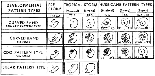
Click here to Order your Radar Equipment Online THE CURVED BAND PATTERN (VISUAL). Intensity estimates obtained from the curved band pattern seen in visual imagery are based on the extent to which the dense overcast cloud band encircles the CSC. At the minimal tropical storm stage, the band is observed to curve about halfway around the center. When the band coils completely around the center, the hurricane stage is attained provided that the required minimum length of developmental time has
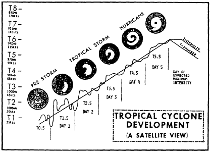
Figure 10-3-13.Development cloud pattern types used in intensity analysis. Pattern changes from left to right are typical 24-hour changes.elapsed. The reason for this is that the coiling occasionally occurs more rapidly than pressure falls are known to occur. Continued strengthen-ing of a hurricane/typhoon results in continued coiling of the curved band or in the formation of a center or eye embedded in the dense overcast that appears central to the band curvature. When an eye is observed, the intensity determination is based on the eye characteristics, the amount of dense overcast surrounding it, and the amount of outer banding surrounding these central features. The curved band pattern is the most common cloud pattern seen in satellite pictures, and figure 10-3-14 shows a model of this pattern used in in-tensity analysis. CURVED BAND PATTERN (EIR). The curved band pattern as seen in EIR imagery is similar to that seen in visual imagery, especially during the early stages of tropical cyclone develop-ment. It is during the weak hurricane stage, when the curved band extends once around the center, that the EIR imagery proves more objective than visual imagery in intensity analysis. It is simpler and more objective and consists primarily of two simple measurements: First, the temperature of the coldest cloud band that completely surrounds the eye, and second, the temperature of the eye itself. Based on these two temperatures, an intensity estimate is made.CENTRAL DENSE OVERCAST (CDO) PATTERN. The CDO pattern is used to deter-mine intensity levels when a dense overcast cloud mass appears over the curved cloud features that define the center or surrounds the eye. When the CDO pattern is observed and no eye is present, the size of the dense cloud mass relates to the intensity level. The CDO size increases with increasing intensity. An eye usually becomes visible with the CDO before the T5 intensifica-tion level is reached. When the CDO contains an eye, the distance the eye is embedded within the CDO determines the intensity estimate.SHEAR PATTERN. Vertical wind shear may prevent the dense, upper-level clouds of a tropical cyclone from coiling around the system center as they do in the curved band patterns. When a shear pattern is observed, it is the curvature of the low cloud lines and their proximity to dense overcast clouds that determine the intensity level. The low cloud center appears off to the side of the dense overcast. When the low cloud lines are circularly curved, parallel, and near the edge of the dense overcast, minimal tropical storm intensity is indicated. The second intensity estimate is determined in steps 4 through 6 (fig. 10-3-12). Step 3 will not be discussed at this time because it deals with a cloud pattern type that indicates a tropical
Figure 10-3-14.Model of
tropical cyclone development used in intensity analysis (curved band
pattern type).
cyclones development has been, or soon will be The intensity estimate determined from the cloud features is then examined according to the rules of the technique to see if it falls within specified limits or if it must be adjusted (steps 7 through 9). The rules, in general, hold the change in intensity close to one T-number a day for the prestorm stage of development and to within one number of the model expected T-number during the later stages of development. The final step in the technique (step 10) pro-vides instructions for making a 24-hour intensity forecast. Forecasting the intensity changes and movement of tropical cyclones is discussed in the AGI rate training manual. Step 3, which we passed over previously, is used when the cloud pattern exhibits a central cold cover. When the CCC is observed, the analysis consists of a simple application of the rules given on page 3 of appendix 2. |
|
Privacy Statement - Press Release - Copyright Information. - Contact Us - Support Integrated Publishing |