|
||
|
|
||
| |||||||||||||||
|
|
Click here to Order your Radar Equipment Online Surface Ridgelines Although these features are not as well defined on satellite pictures as frontal systems, their positions can be determined by the experienced interpreter. The three characteristics of cloud patterns found with surface ridgelines are illustrated in figure 10-3-8.The type A cloud pattern is characterized by long cloud lines, or fingers, that extend in a continuous fashion from a frontal band. Generally, these cloud lines are oriented in a more north-south direction than the frontal band. The end of each cloud line serves as a point for positioning the surface ridgeline. Type A cloud patterns are commonly found along the southwestern side of the subtropical high-pressure centers.The type B cloud pattern is found on the western side of a subtropical high-pressure area where the clouds change in character from cumuliform to stratiform. Notice that the points drawn for the ridgeline are drawn so that they lie along the line where the cloud type changes from cumuliform to stratiform. This change in cloud character is generally found where the low-level wind changes from a southeasterly to a south-westerly direction. As the air moves rapidly poleward, stability increases near the surface, producing the observed change in cloud form. The type C pattern is associated with a sharp migrating surface ridge that lies between two large low-pressure centers in close proximity to each other. Along this ridge, there is a windshift from a generally southwesterly direction to the northwest. The air in the southerly flow cools as it moves north over cooler water and becomes more stable with time. Air in the northerly flow is heated from
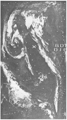
Figure 10-3-7.IR, dissipating vortex. below and becomes unstable. This difference in stability produces two distinctly different cloud patterns, which are readily seen in satellite pictures. The clouds in the southerly flow are primarily stratiform, while those in the northerly flow are cumuliform. The surface ridgeline is located in the narrow region between the two cloud patterns.Another feature that will help you locate a surface ridge over oceanic areas is known as SUN GLINT. Sun glint is created by the Suns reflec-tion off a smooth sea surface, and it occurs most often in the center of elongated high-pressure systems. The ridgeline is oriented in the direction
Figure 10-3-8.Surface
analysis superimposed on satellite pictures showing surface ridgelines.
of the elongated axis of the sun glint. See figure |
|
Privacy Statement - Press Release - Copyright Information. - Contact Us - Support Integrated Publishing |