|
||
|
|
||
|
Page Title:
Extratropical Cyclone Development |
||
| |||||||||||||||
|
|
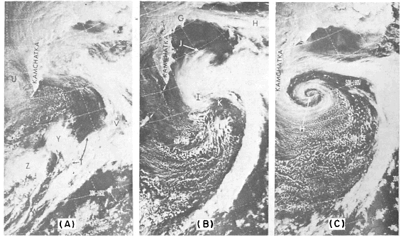
Click here to Order your Radar Equipment Online Extratropical Cyclone Development Twice-a-day surveillance by visual and infrared sensors of polar orbiting environmental satellites permits analysts to monitor developing low-pressure systems at 12-hour intervals, while the geostationary satellite provides 24-hour surveillance at 1/2-hour intervals and permits almost constant monitoring.The typical sequence of events for a develop-ing system is as follows: (1) the initial frontal wave, (2) the deepening stage, (3) the mature stage with or without secondary centers or waves, and (4) the dissipating stage. The first three stages are shown in figure 10-3-6. These photographs were taken on three consecutive days by the NOAA-1 polar orbiting satellite. On day one, a large occluded front stretched from a low center (U) near Kamchatka peninsula, then eastward and southward to near the dateline (V) and then southwestward to W. This frontal band is composed mainly of low and middle stratiform clouds from U to V and more convective clouds southwestward from V to W. To the south of the cyclone center and west of the frontal band, two bright comma-shaped cloud masses (Y and Z) are apparent. As stated earlier, these patterns are in-dicative of secondary centers of positive vorticity and positive vorticity advection (PVA) in the mid troposphere. In this example, the PVA center, at Y, is close to the front and has caused a wave to form at T. As the wave develops, the anticyclonic bulge of the cirrus north of T increases towards the cold air. Note that the most active portion of the front (convective activity) lies east of the vorticity center.By 13 March (day two) the less active portion of the front (north of V on 12 March) was located just south of the Aleutians (G to H), and the wave (T) of yesterday is now the main system (I) in this area. The ongoing intensification of this system
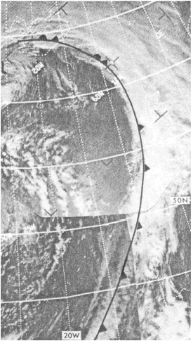
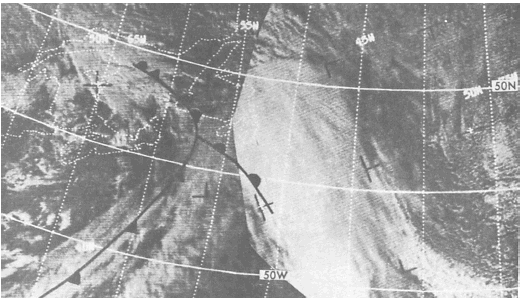
Figure 10-3-4.An active cold front. is indicated by the cirrus outflow (J) in the northern and eastern quadrants and the cloudy vortex center. The nearly clear, dry air slot behind the front has reached K, also indicating the low is intensifying; intensification continues until the dry air spirals into the low center. When the cold, dry air reaches the center, the cloud pattern is most organized. The vortex is classified as being in the mature stage, and the systems central pressure is at or near its lowest point. On day three, the storm has fully occluded. By this time, the clear dry air has made two complete revolutions into the vortex center (H). The cirrus outflow apparent on 13 March is absent, and only a narrow multilayered cloud band remains. A large field of open-celled
Figure 10-3-5.Satellite
photograph showing clouds associated with warm front.
Figure 10-3-6.Development of a Pacific storm. (A) visible. NOAA-2 SR.
orbit 6426.2214 GMT. March 12: (B) cumulus lies in the cold air southeast of the center. The last stage of a vortexs life cycle is the dissipating stage. The low is weakening, and the frontal band is well east of the vortex center. Fragmented and poorly organized cloud bands spiral around the center of the low. The center is usually cloud free except for convective clouds caused by heating from the underlying surface. Figure 10-3-7 illustrates the dissipating stage. |
|
Privacy Statement - Press Release - Copyright Information. - Contact Us - Support Integrated Publishing |