|
||
|
|
||
|
Page Title:
Step 5. The model expected T-Number (MET) |
||
| |||||||||||||||
|
|
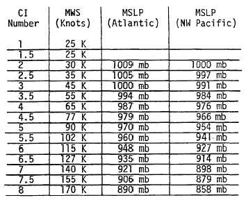
Click here to Order your Radar Equipment Online STEP 5. THE MODEL EXPECTED T-NUMBER (MET). The MET is determined by using the 24-hour old T-number, the D, S, or W decision in Step 4, and the past amount of intensity change of the storm. When the growth rate has not been established in the case of new developments or reversals in trend, assume a past rate of change of one T-number per day. Equations for determining the MET are given below. MET = 24-hour old T-number + (.5 to 1.5) when D was determined. MET = 24-hour old T-number - (.5 to 1.5) when M was determined. MET = 24-hour old T-number when S was determined. Rapid or slow past rates of change are established when two consecutive analyses showing rapid or slow pattern evaluation are observed at 6-hour or more intervals, or when one observation accompanied by signs of strong inten-sification or weakening is observed (see Step 10). STEP 6. THE PATTERN T-NUMBER (PT). The pattern T-number is used primarily as an adjustment to the MET when an adjustment is indicated. The PT-number is determined by choosing the pat-tern that best matches your storm picture from either the model expected T number column or the column on either side of it. When the pattern being analyzed looks more like the pattern in the column to the right or left of the MET column, then raise or lower the MET .5 to determine the PT. STEP 7. RULES FOR DETERMINING THE T-NUMBER Use the data T-number (DT) when the cloud feature measurements are clear-cut. Use the pattern T-number (PT) when the DT is not clear and the pattern is understandable. When neither the DT or the PT is clear, use the Model Expected T-number (MET). STEP 8. FINAL T-NUMBER This step provides the constraints within which the final T-number must fall. In other words, when the T-number gotten from Step 7 does not fall within the stated limits, it must be adjusted to the limits. The constraints hold the final T-number change to 1.5 during the first 24 hours of develop-ment; to 2 numbers in 24 hours for T-numbers T2 to T4 (i.e. 1/2 number over a six hour period); and to 2.5 numbers over a 24 hour period for changes in storms of T4 or greater intensity (i.e. 1 number over a six hour period, 1 1/2 numbers in 12 hours, 2 in 18 hours, and 2.5 in 24 hours). In general for storms of hurricane intensity, the final T-number must be within one number of the model expected T-number (MET). The constraints are listed in the diagram. The rules also prohibit the lowering of the T-number at night during the first 48 hours of development because the diurnal changes in clouds often give deceptive indications of weakening at this time. STEP 9. CURRENT INTENSITY (CI) NUMBER The CI number relates directly to the intensity of the storm. The empirical relationship between the CI number and the storms wind speed is shown in figure 9. Figure 9. The empirical relationship between the current intensity number
(CI), After each intensity analysis, the previous analyses of the storm should be reviewed in the light of the current data. When an error was made in the previous days analysis, correct the T-number to provide a more-accurate model-expected intensity. The correction may at times alter the current intensity analysis. The CI number is the same as the T-number during the development stages of a tropical cyclone but is held higher than the T-number while a cyclone is weakening. This is done because a lag is observed between the time a storm pattern indicates weakening has begun and the time when the storms intensity decreases. In practice, the CI number is not lowered until the T-number has shown weakening for 12 hours or more. The CI number is then held one higher than the T-number as the storm weakens. (Hold the CI number 1/2 number higher when the T-number shows a 24 hour decrease of 1/2 number.) When redevelopment occurs, the CI number is not lowered even if the T-number is lower than the CI number. In this case, let the CI number remain the same until the T-number increases to the value of the CI number.
|
|
Privacy Statement - Press Release - Copyright Information. - Contact Us - Support Integrated Publishing |