 |
||
|
|
||
| |||||||||||||||
|
|
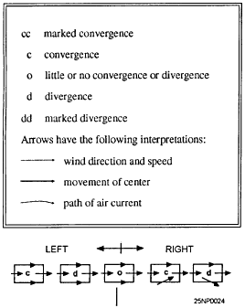
Click here to Order your Radar Equipment Online Orographic Lifting Orographic lifting is the most effective and intensive of all cooling processes. Horizontal motion is converted into vertical motion in proportion to the slope of the inclined surface. Comparatively flat terrain can have a slope of as much as 1 mile in 20 miles. The greatest extremes in rainfall amount and intensity occur at mountain stations. For this reason, it is very important that the forecaster be aware of this potential situation.Frontal Lifting is the term applied to the process represented on a front when the inclined surface represents the boundary between two air masses of different densities. In this case, however, the slope ranges from 1/20 to 1/100 or even less. The steeper the front, the more adverse and intense its effects, other factors being equal. These effects were discussed in detail in the AG2 TRAMAN, volume 1.Vertical Stretching Since it is primarily from properties of the horizontal wind field that vertical stretching is detectable, it is more properly called convergence. This term will be used hereafter.The examples of convergence and divergence, explained in the foregoing, are definite and clear cut, associated as they are with the centers of closed flow patterns. Less easily detected types of convergence and divergence are associated with curved, wave-shaped, or straight flow patterns, where the air is moving in the same general direction. Variations in convergence and divergence are indicated in figures 4-1, 4-2, 4-3, and 4-4 by means of the following key:
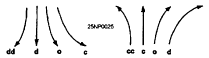
Figure 4-1.-Longitudinal and lateral convergence and divergence.
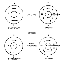
Figure 4-2.-Convergence and divergence in meridional flow. The left side of figure 4-1 illustrates longitudinal convergence and divergence; the right side illustrates lateral convergence and divergence. Many more complicated situations can be analyzed by separation into these components.It can be shown mathematically and verified synoptically that a fairly deep layer of air moving with a north-south component has associated convergence or divergence, depending on its path of movement. In figure 4-2 the arrows indicate paths of meridional flow in the Northern Hemisphere. In general, equatorward flow is divergent unless turning cyclonically, and poleward flow is convergent unless turning anticyclonically.The four diagrams of figure 4-3 represent the approximate distribution of convergence and divergence in Northern Hemispheric cyclones and anticyclones. For moving centers, the greatest convergence or divergence occurs on or near the axis along which the system is moving. The diagrams of figure 4-3 show eastward movement, but they apply regardless of the direction of movement of the center.
Figure 4-3.-Convergence and divergence in lows and highs.
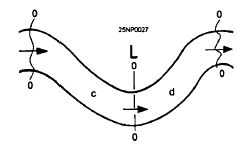
Figure 4-4.-Convergence and divergence in waves. Convergence and divergence are not quite so easily identified in wave-shaped flow patterns because the wave speed of movement is often the factor that determines the distribution. The most common distribution for waves moving toward the east is illustrated in figure 4-4. There is relatively little divergence at the trough and ridge lines, with convergence to the west and divergence to the east of the trough lines.This chapter devotes more time to a discussion of convergence because it is the most difficult characteristic to assess. Its extent ranges from the extremely local convergence of thunderstorm cells and tornadoes to the large-scale convergence of the broad and deep currents of poleward- and equatorward-moving air masses.The amount, type, and intensity of the weather phenomena resulting from any of the lifting processes described in this chapter depend on the stability or convective stability of the air being lifted.All of the lifting mechanisms (orographic, frontal, vertical stretching) can occur in any particular weather situation. Any combination, or all three, are possible, and even probable. For instance, an occluded cyclone of maritime origin moving onto a mountainous west coast of a continent could easily have associated with it warm frontal lifting, cold frontal lifting, orographic lifting, lateral convergence, and convergence in the southerly flow. All fronts have a degree of convergence associated with them.This information is now available on CD in Adobe PDF Printable Format |
|
Privacy Statement - Press Release - Copyright Information. - Contact Us - Support Integrated Publishing |