|
||
|
|
||
| |||||||||||||||
|
|
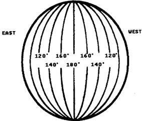
LONGITUDE The point of origin for the vertical lines (longitude) on American and British maps is an imaginary line running from the North Pole to the South Pole through Greenwich, England. Like the Equator, it has a numerical value of 0 degrees. It is called the Greenwich meridian or the prime meridian. Many foreign maps do not use this line as the zero reference. For example, French maps use the Paris meridian, and Italian maps use the Rome meridian. Data from foreign maps must be examined to determine the prime meridian in use. The prime meridian and the 180th meridian divide the Earth into two equal vertical parts-the Eastern Hemisphere to the right of the prime meridian and the Western Hemisphere to the left of the prime meridian.
Figure 3-4.-Meridians of longitude. All of the other lines of longitude are simply called meridians. See figure 3-4. Longitude measurements are relative to the prime meridian. Because the numbering of meridians begins with 0 at the prime meridian and increases to both the east and the west, we must show whether the longitude is east or west of the prime meridian. The value of a meridian is determined by the angle formed by drawing a line from the Equator, at the point where the prime meridian crosses it, to the center of the Earth, and then back out to another point on the Equator. See
Figure 3-5.-Measuring meridians. figure 3-5. The angle formed by the intersection of those two lines is the value assigned to that meridian. In this way, the angles are measured around the Earth in both an east and a west direction until you reach 180. Since there are 180 on each half of the globe, you have a circle of 360. Each degree of longitude is subdivided into minutes and seconds in the same manner as latitude. However, remember two things about longitude: 1. West longitude is measured from right to left on a map; east longitude is measured from left to right. 2. When you write longitude in military notation, use seven numbers plus a letter to indicate east or west. When a position has less than 100 of longitude, a zero is added to the left of the degree number; less than 10, two zeros are added. For example: 0074321W for 7 degrees, 43 minutes, 21 seconds west. |
|
Privacy Statement - Press Release - Copyright Information. - Contact Us - Support Integrated Publishing |