Custom Search
|
|
 
|
||
|
PLOTTING BY COORDINATES. A
common and accurate
method of plotting by coordinates is shown in
figure 7-39. Here you simply locate each station by its coordinates and have no
angular measurements to bother about. To plot station B,
for instance, you would
layoff from O on
the Y axis
a distance equal to the
Y coordinate
of B (847.60
feet). Draw a light line from this point perpendicular to the Y
axis, and measure off on
this line a distance equal to the X
coordinate of B
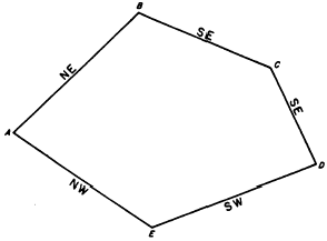
(125.66 feet). The remaining points are plotted in the same way. Mistakes in Computations An involved computation, such as determining an area by DMDs, involves a large number of calculations that present the possibility of a large number of errors. Some of the most common types of mistakes are discussed below in the hope that, if you know what they are, you may be able to avoid them.MISTAKES WITH SIGNS. You must be extremely careful to give a value (such as a latitude or departure) its correct sign in the first place and to apply the sign correctly in addition, subtraction, multi-plication, and division. The matter of signs is such a fertile field for mistakes that a good idea is never to write a value without including the sign. The practice of omitting plus signs is a correct procedure, but it is safer to write in the plus signs. Then, if you find a value without a sign, you know that you forgot to put the sign in and that it might just as possibly be a minus as a plus.WRONG COLUMN. A WRONG COLUMN mistake may be an entry made in a wrong column or a reading taken from a wrong column. To avoid such mistakes, make both entries and readings with deliberation; that is, without undue haste and always with close attention to the column in which it should be entered or read.WRONG QUADRANT. When you mistake the quadrant in which a line lies, you get a bearing that may have the correct angular value but that has the wrong compass direction. The usual mistake of this kind is to set down the compass direction of the back bearing rather than of the front bearing.A common cause of this mistake is viewing the direction of a line from the wrong station. In figure 740, the direction of AB is northeast but the direction of BA is southwest. AB and BA are, however, the same traverse line. But if you are determining the direction of AB, that direction is northeast. But if you are determining the direction of BA, that direction is precisely the opposite, or southwest. To minimize direction error, you may place arrows on the diagram showing the direction of the line.WRONG AZIMUTH. The same consideration applies to azimuths. Suppose that the bearing of AB in figure 7-40 is N46E. Then the azimuth of AB is (measured from north) 46. BA is the same traverse line; but the azimuth of BA is definitely not 46, but 226.LEAVING OUT A TRAVERSE LINE. A common source of mistakes is leaving out (commonly called dropping) a traverse line, either in the field notes
Figure 7-40.Proper compass direction of a closed traverse. or in computations. If you get an outsized angular and linear error of closure, you check first to make sure that you have not dropped one of the traverse lines.WRONG DECIMAL PLACE. The incorrect placement of a decimal point is a common mistake. Suppose, for example, you are determining an approximate double area by multiplying a DMD of +841.97 feet by latitude of 153.53 feet If you were to mistakenly use a value of 1535.3 instead of the correct 153.53, you obviously will not arrive at the correct result. |
 
|
|
|
||